IMAGES TAKEN NEAR TO
Popes Lane, CANTERBURY, CT2 0JZ
Introduction
This page details the photographs taken nearby to Popes Lane, CT2 0JZ by members of the Geograph project.
The Geograph project started in 2005 with the aim of publishing, organising and preserving representative images for every square kilometre of Great Britain, Ireland and the Isle of Man.

There are currently over 7.5m images from over14,400 individuals and you can help contribute to the project by visiting https://www.geograph.org.uk
Image Map
Images are licensed for reuse under creativecommons.org/licenses/by-sa/2.0
Notes
- Clicking on the map will re-center to the selected point.
- The higher the marker number, the further away the image location is from the centre of the postcode.
Image Listing (16 Images Found)
Images are licensed for reuse under creativecommons.org/licenses/by-sa/2.0
Image
Details
Distance
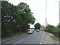
2
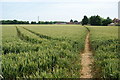
Wheat field near Popes Lane
A handy footpath cuts across the corner from Sweechgate. A line of pylons also crosses here and the cables are just visible top left.
Image: © Bill Boaden
Taken: 28 Jun 2012
0.04 miles
3
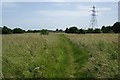
Footpath to Popes Lane
A path which continues from the end of Sweechgate.
Image: © Bill Boaden
Taken: 28 Jun 2012
0.10 miles
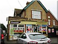
7
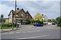
Broad Oak Village Stores
Situated at the eastern end of Sweechgate.
Image: © Bill Boaden
Taken: 28 Jun 2012
0.16 miles
10
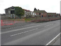
Sweech Farm, Herne Bay Road
Planning permission has been granted by Canterbury City Council under application number CA//10/01299 for the “construction of a pair of two-storey cottages and a two-storey dwelling with associated store, construction of a detached four bay garage building and the conversion of the former oast building to a single dwelling incorporating a roof extension to reconstruct the kiln roof and cowl”.
Planning permission has also been granted by Canterbury City Council under application number CA//17/00679 for an “application for listed building consent for external alterations including roof extension”. This application applies to the oast building.
Image: © John Baker
Taken: 11 Feb 2018
0.18 miles