IMAGES TAKEN NEAR TO
The Coppice, CANTERBURY, CT2 0JU
Introduction
This page details the photographs taken nearby to The Coppice, CT2 0JU by members of the Geograph project.
The Geograph project started in 2005 with the aim of publishing, organising and preserving representative images for every square kilometre of Great Britain, Ireland and the Isle of Man.

There are currently over 7.5m images from over14,400 individuals and you can help contribute to the project by visiting https://www.geograph.org.uk
Image Map
Images are licensed for reuse under creativecommons.org/licenses/by-sa/2.0
Notes
- Clicking on the map will re-center to the selected point.
- The higher the marker number, the further away the image location is from the centre of the postcode.
Image Listing (51 Images Found)
Images are licensed for reuse under creativecommons.org/licenses/by-sa/2.0
Image
Details
Distance
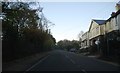
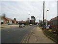
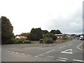
7
Island Road at the junction of Herne Bay Road
The building opposite is new, and was either based on the similar one there before or an extended version of it. Either way none of the current features are original.
Image: © David Howard
Taken: 31 Jul 2016
0.15 miles

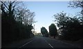
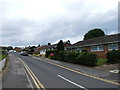
10
Sleigh Road at the junction of Island Road
Image: © David Howard
Taken: 31 Jul 2016
0.16 miles