IMAGES TAKEN NEAR TO
Bushy Hill Road, CANTERBURY, CT2 0HE
Introduction
This page details the photographs taken nearby to Bushy Hill Road, CT2 0HE by members of the Geograph project.
The Geograph project started in 2005 with the aim of publishing, organising and preserving representative images for every square kilometre of Great Britain, Ireland and the Isle of Man.

There are currently over 7.5m images from over14,400 individuals and you can help contribute to the project by visiting https://www.geograph.org.uk
Image Map
Images are licensed for reuse under creativecommons.org/licenses/by-sa/2.0
Notes
- Clicking on the map will re-center to the selected point.
- The higher the marker number, the further away the image location is from the centre of the postcode.
Image Listing (40 Images Found)
Images are licensed for reuse under creativecommons.org/licenses/by-sa/2.0
Image
Details
Distance

6
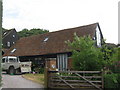
Walnut Tree Barn
Grade II Listed (converted stable) building on Walnut Tree Lane. The main barn is in the background.
See http://www.britishlistedbuildings.co.uk/en-171530-stable-at-east-of-walnut-tree-farmhouse- for more details.
Image: © David Anstiss
Taken: 23 May 2011
0.18 miles
7
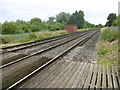
View up the line from the foot crossing near Westbere
On 6th February 1846, the South Eastern Railway began services from Ashford to Canterbury West and two months later in April 1846 services were extended though here to Ramsgate. Electric services started on 9th October 1961 and in December 2009, the line became part of the Southeastern High Speed service to London St Pancras.
The foot crossing between Walnut Tree Lane in Westbere and Westbere Marshes seen at http://www.geograph.org.uk/photo/2797769 has been moved about a quarter of a mile to the east with a long trek either side of the line to and from the previous crossing point. This may have been for safety reasons as the previous crossing had very poor sightlines for down trains from the west which veered round a curve to reach the crossing. See also http://www.geograph.org.uk/photo/5029212 The next station in this direction is Sturry.
Image: © Marathon
Taken: 7 Jul 2016
0.19 miles
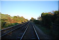
9
Foot crossing near Westbere
On 6th February 1846, the South Eastern Railway began services from Ashford to Canterbury West and two months later in April 1846 services were extended though here to Ramsgate. Electric services started on 9th October 1961 and in December 2009, the line became part of the Southeastern High Speed service to London St Pancras.
The foot crossing between Walnut Tree Lane in Westbere and Westbere Marshes seen at http://www.geograph.org.uk/photo/2797769 has been moved about a quarter of a mile to the east with a long trek either side of the line to and from the previous crossing point. This may have been for safety reasons as the previous crossing had very poor sightlines for down trains from the west which veered round a curve to reach the crossing.
Image: © Marathon
Taken: 7 Jul 2016
0.19 miles
10
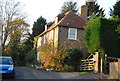
Walnut Tree Farmhouse
Grade II listed. http://www.britishlistedbuildings.co.uk/en-171528-walnut-tree-farmhouse-1-westbere
Image: © N Chadwick
Taken: 19 Nov 2011
0.19 miles