IMAGES TAKEN NEAR TO
CT2 0FG
Introduction
This page details the photographs taken nearby to CT2 0FG by members of the Geograph project.
The Geograph project started in 2005 with the aim of publishing, organising and preserving representative images for every square kilometre of Great Britain, Ireland and the Isle of Man.

There are currently over 7.5m images from over14,400 individuals and you can help contribute to the project by visiting https://www.geograph.org.uk
Image Map
Images are licensed for reuse under creativecommons.org/licenses/by-sa/2.0
Notes
- Clicking on the map will re-center to the selected point.
- The higher the marker number, the further away the image location is from the centre of the postcode.
Image Listing (18 Images Found)
Images are licensed for reuse under creativecommons.org/licenses/by-sa/2.0
Image
Details
Distance
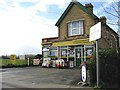
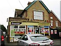
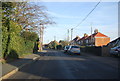
4
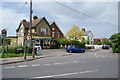
Broad Oak Village Stores
Situated at the eastern end of Sweechgate.
Image: © Bill Boaden
Taken: 28 Jun 2012
0.07 miles
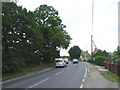
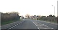
9
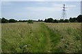
Footpath to Popes Lane
A path which continues from the end of Sweechgate.
Image: © Bill Boaden
Taken: 28 Jun 2012
0.11 miles