IMAGES TAKEN NEAR TO
Blengate Close, CANTERBURY, CT2 0FE
Introduction
This page details the photographs taken nearby to Blengate Close, CT2 0FE by members of the Geograph project.
The Geograph project started in 2005 with the aim of publishing, organising and preserving representative images for every square kilometre of Great Britain, Ireland and the Isle of Man.

There are currently over 7.5m images from over14,400 individuals and you can help contribute to the project by visiting https://www.geograph.org.uk
Image Map
Images are licensed for reuse under creativecommons.org/licenses/by-sa/2.0
Notes
- Clicking on the map will re-center to the selected point.
- The higher the marker number, the further away the image location is from the centre of the postcode.
Image Listing (13 Images Found)
Images are licensed for reuse under creativecommons.org/licenses/by-sa/2.0
Image
Details
Distance
1
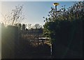
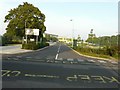
Spires Academy School Entrance Gate
The remains of the main entrance to the old Spires Academy site. The original build was demolished in late 2017. I studied here and remember the place very well. It will soon become yet another building site for homes. For reference the Schools prior name was The Frank Montgomery School.
Image: © Matt Allsop
Taken: 28 Dec 2017
0.05 miles
2
Former Spires Academy, Bredlands Lane
This academy closed in July 2012 http://en.wikipedia.org/wiki/Spires_Academy
Image: © John Baker
Taken: 18 Sep 2014
0.05 miles
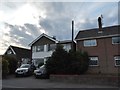
3

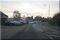
Spires Academy Staff Car Park
Shot taken from the top of Bredlands Lane. The background featured the main section of the Spires Academy building, the foreground to the left was the staff car park. The original site was demolished in late 2017. I studied here and remember the place very well. It will soon become yet another building site for homes. For reference the Schools prior name was The Frank Montgomery School.
Image: © Matt Allsop
Taken: 28 Dec 2017
0.08 miles
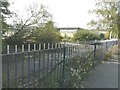
6
Spires Academy, Bredlands Lane
This academy opened in September 2012 http://en.wikipedia.org/wiki/Spires_Academy having been situated on the other side of the road Image
Image: © John Baker
Taken: 18 Sep 2014
0.14 miles
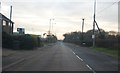
7

Vauxhall garage on Staines Hill, Westbere
Image: © David Howard
Taken: 31 Jul 2016
0.18 miles
9

Vauxhall dealership at Westbere
Part of the development along the A28 which fortunately leaves Westbere village unaffected.
Image: © Bill Boaden
Taken: 28 Jun 2012
0.19 miles
10
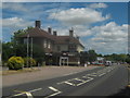
Spice Master
Converted Pub on the A28 Island Road.
It used to be the Westbere Butts.
Now a Bangladeshi Indian Cuisine Restaurant.
Image: © David Anstiss
Taken: 11 Jul 2010
0.24 miles