IMAGES TAKEN NEAR TO
Moat Lane, CANTERBURY, CT2 0DR
Introduction
This page details the photographs taken nearby to Moat Lane, CT2 0DR by members of the Geograph project.
The Geograph project started in 2005 with the aim of publishing, organising and preserving representative images for every square kilometre of Great Britain, Ireland and the Isle of Man.

There are currently over 7.5m images from over14,400 individuals and you can help contribute to the project by visiting https://www.geograph.org.uk
Image Map
Images are licensed for reuse under creativecommons.org/licenses/by-sa/2.0
Notes
- Clicking on the map will re-center to the selected point.
- The higher the marker number, the further away the image location is from the centre of the postcode.
Image Listing (24 Images Found)
Images are licensed for reuse under creativecommons.org/licenses/by-sa/2.0
Image
Details
Distance
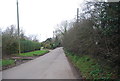
1

Bungalow on Moat Lane, Fordwich
It looks more like a shed to me.
Image: © David Howard
Taken: 21 Mar 2020
0.00 miles
3
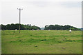
Field of Horses off Stodmarsh Road
Image: © Oast House Archive
Taken: 24 Jun 2010
0.08 miles
4
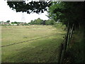
Footpath towards Stodmarsh Road
A footpath leads around a field along the road towards the junction with Moat Lane.
Image: © David Anstiss
Taken: 15 Aug 2010
0.10 miles
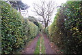
6
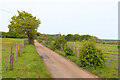
Well Lane
View along Well Lane, towards Fordwich.
Image: © Wayland Smith
Taken: 2 May 2022
0.13 miles