IMAGES TAKEN NEAR TO
Mill Road, CANTERBURY, CT2 0AL
Introduction
This page details the photographs taken nearby to Mill Road, CT2 0AL by members of the Geograph project.
The Geograph project started in 2005 with the aim of publishing, organising and preserving representative images for every square kilometre of Great Britain, Ireland and the Isle of Man.

There are currently over 7.5m images from over14,400 individuals and you can help contribute to the project by visiting https://www.geograph.org.uk
Image Map
Images are licensed for reuse under creativecommons.org/licenses/by-sa/2.0
Notes
- Clicking on the map will re-center to the selected point.
- The higher the marker number, the further away the image location is from the centre of the postcode.
Image Listing (218 Images Found)
Images are licensed for reuse under creativecommons.org/licenses/by-sa/2.0
Image
Details
Distance
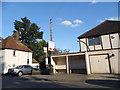
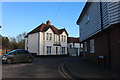
1
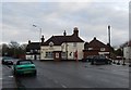
New pub on Mill Road, Sturry
This is the first time I've come across a house which was converted to a pub. In 2014 it was a house, that was the back door and the barn is new.
Image: © David Howard
Taken: 31 Jul 2016
0.01 miles
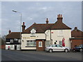
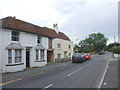
5
Welsh Harp, Sturry
Roadside inn, in this Kentish village
Image: © N Chadwick
Taken: 27 Sep 2008
0.02 miles
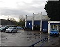
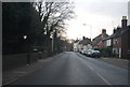
6
Water Lane at the junction of Fordwich Road
Image: © David Howard
Taken: 21 Mar 2020
0.02 miles
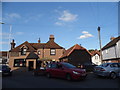
7
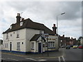
The Welsh Harp Public House, Sturry
On junction of A28 Mill Road (on right) and Fordwich Road (on left).
Image: © David Anstiss
Taken: 13 Jul 2009
0.02 miles