IMAGES TAKEN NEAR TO
Mill Road, CANTERBURY, CT2 0AB
Introduction
This page details the photographs taken nearby to Mill Road, CT2 0AB by members of the Geograph project.
The Geograph project started in 2005 with the aim of publishing, organising and preserving representative images for every square kilometre of Great Britain, Ireland and the Isle of Man.

There are currently over 7.5m images from over14,400 individuals and you can help contribute to the project by visiting https://www.geograph.org.uk
Image Map
Images are licensed for reuse under creativecommons.org/licenses/by-sa/2.0
Notes
- Clicking on the map will re-center to the selected point.
- The higher the marker number, the further away the image location is from the centre of the postcode.
Image Listing (95 Images Found)
Images are licensed for reuse under creativecommons.org/licenses/by-sa/2.0
Image
Details
Distance
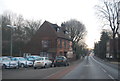
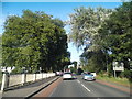
3
Entering Sturry on Back Hill Bridge
Crossing the River Stour
Image: © David Howard
Taken: 21 Mar 2020
0.03 miles
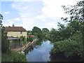
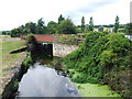
10
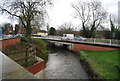
Black Mill Bridge, Mill Rd
The A28 crossing the Great Stour outside Sturry
Image: © N Chadwick
Taken: 12 Dec 2009
0.05 miles