IMAGES TAKEN NEAR TO
CT20 3XH
Introduction
This page details the photographs taken nearby to CT20 3XH by members of the Geograph project.
The Geograph project started in 2005 with the aim of publishing, organising and preserving representative images for every square kilometre of Great Britain, Ireland and the Isle of Man.

There are currently over 7.5m images from over14,400 individuals and you can help contribute to the project by visiting https://www.geograph.org.uk
Image Map
Images are licensed for reuse under creativecommons.org/licenses/by-sa/2.0
Notes
- Clicking on the map will re-center to the selected point.
- The higher the marker number, the further away the image location is from the centre of the postcode.
Image Listing (16 Images Found)
Images are licensed for reuse under creativecommons.org/licenses/by-sa/2.0
Image
Details
Distance
1
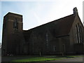
The Tower Theatre, Cheriton
The Tower Theatre was formerly St Marks, the old Garrison Church located on North Road, Shorncliffe, within Shorncliff Camp.
See http://www.towertheatrefolkestone.co.uk/ for more details.
Image: © David Anstiss
Taken: 19 Nov 2010
0.10 miles
2
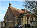
The Tower Theatre (2)
The Tower Theatre was formerly St Marks, the old Garrison Church located on North Road, Shorncliffe, within the Shorncliff Camp.
See http://www.towertheatrefolkestone.co.uk/ for more details.
Image: © David Anstiss
Taken: 19 Nov 2010
0.10 miles
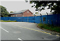
3

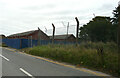
Nearne Way
Part of a housing estate for which planning permission has been approved, with conditions, by Folkestone and Hythe District Council under application number Y19/0318/FH for the “erection of 355 dwellings along with associated landscaping, infrastructure and earthworks at phases 2C and 4, Burgoyne Barracks North and Napier Barracks, pursuant to outline planning permission Y14/0300/SH”.
The setting sun was illuminating the houses.
Image: © John Baker
Taken: 9 Nov 2022
0.10 miles
4
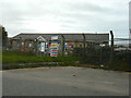
Burgoyne Barracks
Viewed from West Road.
Planning permission has been approved, with conditions, by Folkestone and Hythe District Council under application number Y19/0318/FH for the “erection of 355 dwellings along with associated landscaping, infrastructure and earthworks at phases 2C and 4, Burgoyne Barracks North and Napier Barracks, pursuant to outline planning permission Y14/0300/SH”.
Image: © John Baker
Taken: 16 Oct 2022
0.13 miles
5
Burgoyne Barracks
Viewed from West Road.
Planning permission has been approved, with conditions, by Folkestone and Hythe District Council under application number Y19/0318/FH for the “erection of 355 dwellings along with associated landscaping, infrastructure and earthworks at phases 2C and 4, Burgoyne Barracks North and Napier Barracks, pursuant to outline planning permission Y14/0300/SH”.
Image: © John Baker
Taken: 16 Oct 2022
0.14 miles
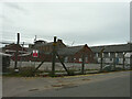
6
Napier Barracks
Planning permission has been approved, with conditions, by Folkestone and Hythe District Council under application number Y19/0318/FH for the “erection of 355 dwellings along with associated landscaping, infrastructure and earthworks at phases 2C and 4, Burgoyne Barracks North and Napier Barracks, pursuant to outline planning permission Y14/0300/SH”.
This is one of the entrances from North Road.
Image: © John Baker
Taken: 25 Sep 2022
0.15 miles
7
Burgoyne Barracks
Viewed from West Road, the white-painted building is the same as in this view of Image
Planning permission has been approved, with conditions, by Folkestone and Hythe District Council under application number Y19/0318/FH for the “erection of 355 dwellings along with associated landscaping, infrastructure and earthworks at phases 2C and 4, Burgoyne Barracks North and Napier Barracks, pursuant to outline planning permission Y14/0300/SH”.
Image: © John Baker
Taken: 16 Oct 2022
0.16 miles
8
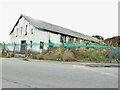
Burgoyne Barracks
Viewed from the entrance to Shorncliffe Military Cemetery, the building used to be an Army gymnasium.
Planning permission has been approved, with conditions, by Folkestone and Hythe District Council under application number Y19/0318/FH for the “erection of 355 dwellings along with associated landscaping, infrastructure and earthworks at phases 2C and 4, Burgoyne Barracks North and Napier Barracks, pursuant to outline planning permission Y14/0300/SH”.
Image: © John Baker
Taken: 25 Sep 2022
0.17 miles
9

Shorncliffe Camp Cricket ground
As seen from North Road. The pavilion is on the left.
Risborough barracks is in the background.
Image: © David Anstiss
Taken: 19 Nov 2010
0.20 miles
10
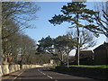
Royal Military Avenue
North of the Shorncliffe Camp. Some disused barrack buildings and a water tower are to the left.
Image: © Oast House Archive
Taken: 8 Apr 2010
0.21 miles