IMAGES TAKEN NEAR TO
Encombe, FOLKESTONE, CT20 3TT
Introduction
This page details the photographs taken nearby to Encombe, CT20 3TT by members of the Geograph project.
The Geograph project started in 2005 with the aim of publishing, organising and preserving representative images for every square kilometre of Great Britain, Ireland and the Isle of Man.

There are currently over 7.5m images from over14,400 individuals and you can help contribute to the project by visiting https://www.geograph.org.uk
Image Map
Images are licensed for reuse under creativecommons.org/licenses/by-sa/2.0
Notes
- Clicking on the map will re-center to the selected point.
- The higher the marker number, the further away the image location is from the centre of the postcode.
Image Listing (153 Images Found)
Images are licensed for reuse under creativecommons.org/licenses/by-sa/2.0
Image
Details
Distance
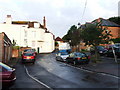
1
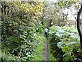
Shorncliffe, Public Footpath No. HF56
Image: © Helmut Zozmann
Taken: 20 Jul 2012
0.03 miles
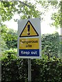
2
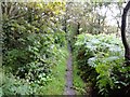
Shorncliffe, Public Footpath No. HF56
Image: © Helmut Zozmann
Taken: 20 Jul 2012
0.04 miles
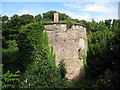
3
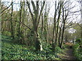
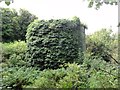
Track to Martello Tower No. 6
A track leads from Martello Tower No.8 (via No.7) to the tower near Military Road. Leading through the wood near Sir John Moore Camp.
Image: © David Anstiss
Taken: 19 Nov 2010
0.06 miles
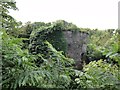
5
Martello Tower number 7, Folkestone
Image: © Oast House Archive
Taken: 18 Jul 2010
0.08 miles