IMAGES TAKEN NEAR TO
Upper Corniche, FOLKESTONE, CT20 3TB
Introduction
This page details the photographs taken nearby to Upper Corniche, CT20 3TB by members of the Geograph project.
The Geograph project started in 2005 with the aim of publishing, organising and preserving representative images for every square kilometre of Great Britain, Ireland and the Isle of Man.

There are currently over 7.5m images from over14,400 individuals and you can help contribute to the project by visiting https://www.geograph.org.uk
Image Map
Images are licensed for reuse under creativecommons.org/licenses/by-sa/2.0
Notes
- Clicking on the map will re-center to the selected point.
- The higher the marker number, the further away the image location is from the centre of the postcode.
Image Listing (112 Images Found)
Images are licensed for reuse under creativecommons.org/licenses/by-sa/2.0
Image
Details
Distance
1
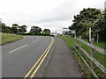
Shorncliffe, Hospital Hill
Folkestone, Shornecliffe Camp, Hospital Hill near Martello Tower No. 8.
Image: © Helmut Zozmann
Taken: 18 Jul 2011
0.05 miles
2
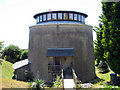
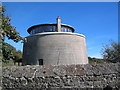
Martello Tower number 8, Folkestone
Converted to a dwelling. A roof has been added to the top to create additional accommodation.
Image: © Oast House Archive
Taken: 11 Jul 2010
0.05 miles
3
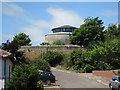
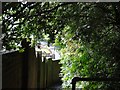
Martello Tower number 8, Folkestone
Looking along Upper Corniche.
Image: © Oast House Archive
Taken: 11 Jul 2010
0.05 miles
4
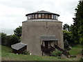
Shorncliffe, Martello Tower No. 8
Folkestone, Shorncliffe Garrison, Martello Tower No. 8 was converted into a residence and is situated amongst other housing near Shorncliffe Camp.
Image: © Helmut Zozmann
Taken: 18 Jul 2011
0.06 miles
6
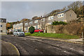
Castle Bay
1970s housing above The Esplanade.
Image: © Ian Capper
Taken: 16 Jan 2017
0.11 miles
7
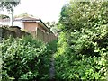
Sandgate, Brewer's Hill
Sandgate, Brewer's Hill, Public Footpath No. HF47.
Image: © Helmut Zozmann
Taken: 20 Jul 2012
0.12 miles
8
Sandgate, Brewer's Hill
Sandgate, Brewer's Hill, Public Footpath No. HF47.
Image: © Helmut Zozmann
Taken: 20 Jul 2012
0.12 miles
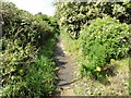
9
Sandgate, Brewer's Hill
Sandgate, Brewer's Hill, Public Footpath No. HF47.
Image: © Helmut Zozmann
Taken: 20 Jul 2012
0.12 miles
10
Martello Tower 8
On the outskirts of Shorncliffe Camp
Image: © Steve Popple
Taken: 9 Oct 2005
0.13 miles