IMAGES TAKEN NEAR TO
Shorncliffe Road, FOLKESTONE, CT20 3PR
Introduction
This page details the photographs taken nearby to Shorncliffe Road, CT20 3PR by members of the Geograph project.
The Geograph project started in 2005 with the aim of publishing, organising and preserving representative images for every square kilometre of Great Britain, Ireland and the Isle of Man.

There are currently over 7.5m images from over14,400 individuals and you can help contribute to the project by visiting https://www.geograph.org.uk
Image Map
Images are licensed for reuse under creativecommons.org/licenses/by-sa/2.0
Notes
- Clicking on the map will re-center to the selected point.
- The higher the marker number, the further away the image location is from the centre of the postcode.
Image Listing (46 Images Found)
Images are licensed for reuse under creativecommons.org/licenses/by-sa/2.0
Image
Details
Distance
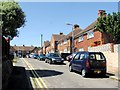
1
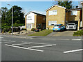
Houses, Shorncliffe Road
The detached house is number 232, while to its right is number 230.
Image: © John Baker
Taken: 17 Sep 2023
0.03 miles
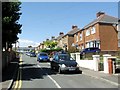
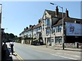
8
43, High Street
Image: © John Baker
Taken: 10 Apr 2019
0.15 miles
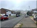
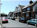
10
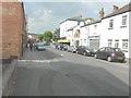
Looking north along Broomfield Road
On the right side of the road, the ground floor window of Music City has been boarded over.
Image: © John Baker
Taken: 1 Jun 2014
0.15 miles