IMAGES TAKEN NEAR TO
Risborough Lane, FOLKESTONE, CT20 3LX
Introduction
This page details the photographs taken nearby to Risborough Lane, CT20 3LX by members of the Geograph project.
The Geograph project started in 2005 with the aim of publishing, organising and preserving representative images for every square kilometre of Great Britain, Ireland and the Isle of Man.

There are currently over 7.5m images from over14,400 individuals and you can help contribute to the project by visiting https://www.geograph.org.uk
Image Map
Images are licensed for reuse under creativecommons.org/licenses/by-sa/2.0
Notes
- Clicking on the map will re-center to the selected point.
- The higher the marker number, the further away the image location is from the centre of the postcode.
Image Listing (11 Images Found)
Images are licensed for reuse under creativecommons.org/licenses/by-sa/2.0
Image
Details
Distance
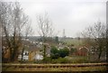
2
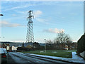
Pylon by Risborough Lane
It was a cold and frosty morning.
Image: © Robin Webster
Taken: 16 Jan 2013
0.15 miles
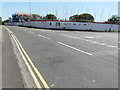
3
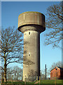
Water Tower on Royal Military Avenue
Image: © Oast House Archive
Taken: 8 Apr 2010
0.17 miles
6
Royal Military Avenue
North of the Shorncliffe Camp. Some disused barrack buildings and a water tower are to the left.
Image: © Oast House Archive
Taken: 8 Apr 2010
0.20 miles
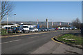
10
Building site, Military Road
Planning permission was approved, with conditions, by Folkestone and Hythe District Council under application number Y16/0463/SH for a “proposed development of 23 dwellings and 18 flats, together with associated access and landscaping, following demolition of the existing building”. This was the Shepway Resource Centre.
Image: © John Baker
Taken: 18 Jun 2017
0.25 miles