IMAGES TAKEN NEAR TO
Risborough Lane, FOLKESTONE, CT20 3LL
Introduction
This page details the photographs taken nearby to Risborough Lane, CT20 3LL by members of the Geograph project.
The Geograph project started in 2005 with the aim of publishing, organising and preserving representative images for every square kilometre of Great Britain, Ireland and the Isle of Man.

There are currently over 7.5m images from over14,400 individuals and you can help contribute to the project by visiting https://www.geograph.org.uk
Image Map
Images are licensed for reuse under creativecommons.org/licenses/by-sa/2.0
Notes
- Clicking on the map will re-center to the selected point.
- The higher the marker number, the further away the image location is from the centre of the postcode.
Image Listing (11 Images Found)
Images are licensed for reuse under creativecommons.org/licenses/by-sa/2.0
Image
Details
Distance
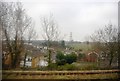
1
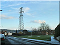
Pylon by Risborough Lane
It was a cold and frosty morning.
Image: © Robin Webster
Taken: 16 Jan 2013
0.06 miles
10

Land adjoining 49, Enbrook Valley
Planning permission has been approved, with conditions, by Folkestone and Hythe District Council under application number 22/0255/FH for a “proposed 3 bedroom chalet bungalow and associated off site parking”.
Image: © John Baker
Taken: 24 Jul 2022
0.24 miles