IMAGES TAKEN NEAR TO
Horn Street, FOLKESTONE, CT20 3JJ
Introduction
This page details the photographs taken nearby to Horn Street, CT20 3JJ by members of the Geograph project.
The Geograph project started in 2005 with the aim of publishing, organising and preserving representative images for every square kilometre of Great Britain, Ireland and the Isle of Man.

There are currently over 7.5m images from over14,400 individuals and you can help contribute to the project by visiting https://www.geograph.org.uk
Image Map
Images are licensed for reuse under creativecommons.org/licenses/by-sa/2.0
Notes
- Clicking on the map will re-center to the selected point.
- The higher the marker number, the further away the image location is from the centre of the postcode.
Image Listing (40 Images Found)
Images are licensed for reuse under creativecommons.org/licenses/by-sa/2.0
Image
Details
Distance
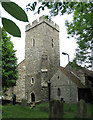
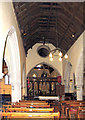
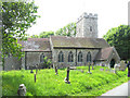
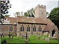
2

Cheriton church
St. Martin's is a grade I listed building, oldest parts 13th century.
Image: © Robin Webster
Taken: 18 Nov 2018
0.05 miles
3
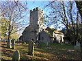
Cheriton church
St. Martin's is a grade I listed building, oldest parts 13th century.
Image: © Robin Webster
Taken: 18 Nov 2018
0.05 miles
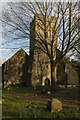
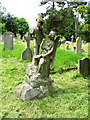
5
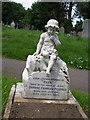
Ornate headstone in the churchyard
There are many lovely examples like this, all in good condition and I couldn't see any that were deliberately laid down because of Health and Safety rules.
Image: © Carol Rose
Taken: 31 May 2007
0.05 miles