IMAGES TAKEN NEAR TO
Aldridge Road, FOLKESTONE, CT20 3FR
Introduction
This page details the photographs taken nearby to Aldridge Road, CT20 3FR by members of the Geograph project.
The Geograph project started in 2005 with the aim of publishing, organising and preserving representative images for every square kilometre of Great Britain, Ireland and the Isle of Man.

There are currently over 7.5m images from over14,400 individuals and you can help contribute to the project by visiting https://www.geograph.org.uk
Image Map
Images are licensed for reuse under creativecommons.org/licenses/by-sa/2.0
Notes
- Clicking on the map will re-center to the selected point.
- The higher the marker number, the further away the image location is from the centre of the postcode.
Image Listing (20 Images Found)
Images are licensed for reuse under creativecommons.org/licenses/by-sa/2.0
Image
Details
Distance
2
The Stadium field at Risborough Barracks
Image: © Carol Rose
Taken: 31 May 2007
0.11 miles
5
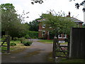
Risborough House next to Risborough barracks
Image: © Carol Rose
Taken: 31 May 2007
0.17 miles
6
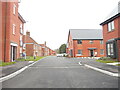
Colonel Drive
Part of a housing estate built on the former Risborough Barracks.
Taken during a photographic outing on New Year's Day afternoon.
Image: © John Baker
Taken: 1 Jan 2023
0.18 miles
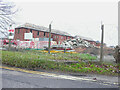
7
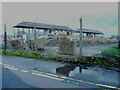
Risborough Barracks, Pond Hill Road
Planning permission has been approved, with conditions, by Folkestone and Hythe District Council under application number 21/1618/FH for an “application for the approval of reserved matters – means of access, appearance, layout, landscaping and scale, for the erection of 230 dwellings together with associated infrastructure and earthworks (pursuant to outline planning permission reference Y14/0300/SH)”.
The development has been given the name Shorncliffe Heights.
A similar view of Image was taken on New Year's Day, when the buildings were still intact.
Image: © John Baker
Taken: 8 Jan 2023
0.19 miles
8
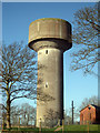
Water Tower on Royal Military Avenue
Image: © Oast House Archive
Taken: 8 Apr 2010
0.21 miles
9
Risborough Barracks, Pond Hill Road
Planning permission has been approved, with conditions, by Folkestone and Hythe District Council under application number 21/1618/FH for an “application for the approval of reserved matters – means of access, appearance, layout, landscaping and scale, for the erection of 230 dwellings together with associated infrastructure and earthworks (pursuant to outline planning permission reference Y14/0300/SH)”.
The development has been given the name Shorncliffe Heights.
A similar view of Image was taken in September 2022 before work began to demolish the barracks.
Taken during a photographic outing on New Year's Day afternoon.
Image: © John Baker
Taken: 1 Jan 2023
0.21 miles
10
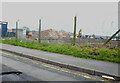
Reduced to a heap of rubble
Included were these buildings at Image and also these at Image by Image
The development has been given the name Shorncliffe Heights.
Image: © John Baker
Taken: 29 Jan 2023
0.21 miles