IMAGES TAKEN NEAR TO
Church Road, FOLKESTONE, CT20 3EW
Introduction
This page details the photographs taken nearby to Church Road, CT20 3EW by members of the Geograph project.
The Geograph project started in 2005 with the aim of publishing, organising and preserving representative images for every square kilometre of Great Britain, Ireland and the Isle of Man.

There are currently over 7.5m images from over14,400 individuals and you can help contribute to the project by visiting https://www.geograph.org.uk
Image Map
Images are licensed for reuse under creativecommons.org/licenses/by-sa/2.0
Notes
- Clicking on the map will re-center to the selected point.
- The higher the marker number, the further away the image location is from the centre of the postcode.
Image Listing (25 Images Found)
Images are licensed for reuse under creativecommons.org/licenses/by-sa/2.0
Image
Details
Distance
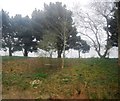
1
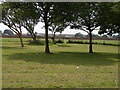
The Stadium field at Risborough Barracks
Image: © Carol Rose
Taken: 31 May 2007
0.08 miles
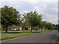
5
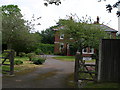
Risborough House next to Risborough barracks
Image: © Carol Rose
Taken: 31 May 2007
0.12 miles
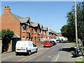
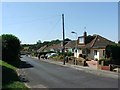
8
Building site, Cheriton
A Wimpey development on former military spare ground. It is called Valley View.
Image: © Robin Webster
Taken: 18 Nov 2018
0.14 miles
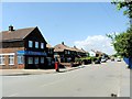
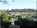
10
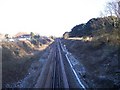
Railway to Folkestone
This line leads from Ashford to Folkestone West and Folkestone Central before heading to Dover. Seen from Horn Street Road bridge. In the background is a footbridge near St Martins Road.
Image: © David Anstiss
Taken: 30 Jan 2010
0.17 miles