IMAGES TAKEN NEAR TO
Broadview, FOLKESTONE, CT20 3ES
Introduction
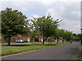
This page details the photographs taken nearby to Broadview, CT20 3ES by members of the Geograph project.
The Geograph project started in 2005 with the aim of publishing, organising and preserving representative images for every square kilometre of Great Britain, Ireland and the Isle of Man.

There are currently over 7.5m images from over14,400 individuals and you can help contribute to the project by visiting https://www.geograph.org.uk
Image Map
Images are licensed for reuse under creativecommons.org/licenses/by-sa/2.0
Notes
- Clicking on the map will re-center to the selected point.
- The higher the marker number, the further away the image location is from the centre of the postcode.
Image Listing (35 Images Found)
Images are licensed for reuse under creativecommons.org/licenses/by-sa/2.0
Image
Details
Distance
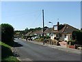
8
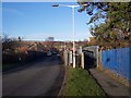
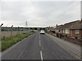
Horn Street road and foot bridges over the railway.
Horn Street heads from Seabrook Road, through Horn Street to Cheriton High Street. The North Downs are in the background. The road bridge is only wide enough for one car at a time.
Image: © David Anstiss
Taken: 30 Jan 2010
0.09 miles
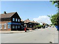
9
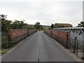
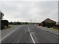
Folkestone, Horn Street
Folkestone, Horn Street railway bridge.
Image: © Helmut Zozmann
Taken: 2 Aug 2011
0.10 miles