IMAGES TAKEN NEAR TO
Church Road, FOLKESTONE, CT20 3EN
Introduction
This page details the photographs taken nearby to Church Road, CT20 3EN by members of the Geograph project.
The Geograph project started in 2005 with the aim of publishing, organising and preserving representative images for every square kilometre of Great Britain, Ireland and the Isle of Man.

There are currently over 7.5m images from over14,400 individuals and you can help contribute to the project by visiting https://www.geograph.org.uk
Image Map
Images are licensed for reuse under creativecommons.org/licenses/by-sa/2.0
Notes
- Clicking on the map will re-center to the selected point.
- The higher the marker number, the further away the image location is from the centre of the postcode.
Image Listing (20 Images Found)
Images are licensed for reuse under creativecommons.org/licenses/by-sa/2.0
Image
Details
Distance
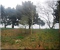
2
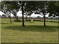
The Stadium field at Risborough Barracks
Image: © Carol Rose
Taken: 31 May 2007
0.11 miles
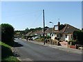
4
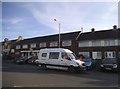
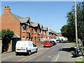
Houses on Cheriton High Street
They call it 'considerate parking'.
Image: © David Howard
Taken: 10 Apr 2016
0.15 miles