IMAGES TAKEN NEAR TO
Castle Bay, FOLKESTONE, CT20 3DU
Introduction
This page details the photographs taken nearby to Castle Bay, CT20 3DU by members of the Geograph project.
The Geograph project started in 2005 with the aim of publishing, organising and preserving representative images for every square kilometre of Great Britain, Ireland and the Isle of Man.

There are currently over 7.5m images from over14,400 individuals and you can help contribute to the project by visiting https://www.geograph.org.uk
Image Map
Images are licensed for reuse under creativecommons.org/licenses/by-sa/2.0
Notes
- Clicking on the map will re-center to the selected point.
- The higher the marker number, the further away the image location is from the centre of the postcode.
Image Listing (126 Images Found)
Images are licensed for reuse under creativecommons.org/licenses/by-sa/2.0
Image
Details
Distance
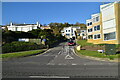
1
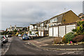
Castle Bay
1960s or early 1970s housing above The Esplanade.
Image: © Ian Capper
Taken: 16 Jan 2017
0.00 miles
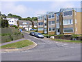
2
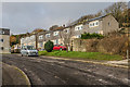
Castle Bay
1970s housing above The Esplanade.
Image: © Ian Capper
Taken: 16 Jan 2017
0.03 miles

4
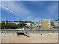
Castle Bay at Sandgate
Sandgate Esplanade is just above the beach. Beyond in this photograph is Castle Bay as it bends up the hill.
Image: © Marathon
Taken: 11 Jun 2017
0.04 miles
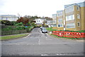
7
Castle Bay
The view from the beach on Sandgate Esplanade.
Image: © Gordon Griffiths
Taken: 29 May 2012
0.05 miles
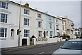
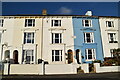
10

Gloster Terrace
Mid Victorian terrace on The Esplanade, originally named Gloucester Terrace.
Image: © Ian Capper
Taken: 16 Jan 2017
0.05 miles