IMAGES TAKEN NEAR TO
Sandgate High Street, FOLKESTONE, CT20 3AR
Introduction
This page details the photographs taken nearby to Sandgate High Street, CT20 3AR by members of the Geograph project.
The Geograph project started in 2005 with the aim of publishing, organising and preserving representative images for every square kilometre of Great Britain, Ireland and the Isle of Man.

There are currently over 7.5m images from over14,400 individuals and you can help contribute to the project by visiting https://www.geograph.org.uk
Image Map
Images are licensed for reuse under creativecommons.org/licenses/by-sa/2.0
Notes
- Clicking on the map will re-center to the selected point.
- The higher the marker number, the further away the image location is from the centre of the postcode.
Image Listing (160 Images Found)
Images are licensed for reuse under creativecommons.org/licenses/by-sa/2.0
Image
Details
Distance
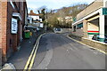
4
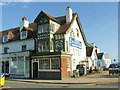
The Chichester Memorial Hall, Sandgate High Street
Image: © David Howard
Taken: 10 Apr 2016
0.03 miles
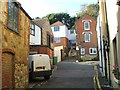
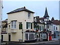
6

The Ship Inn, Sandgate
On the corner of Sandgate High Street and Granville Road West.
Image: © pam fray
Taken: 24 Feb 2017
0.03 miles
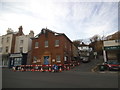
7
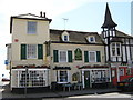
Providence Inn, Sandgate
On junction of 48 Sandgate High Street (in front) and Sea Parade (on left).
Image: © David Anstiss
Taken: 25 Apr 2009
0.03 miles
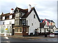
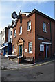
10
Harrisons, 53, Sandgate High Street
Planning permission was approved, with conditions, by Folkestone and Hythe District Council under application number Y16/1345/SH for the “change of use and conversion of part of ground floor retail (Class A1) to residential (Class C3) to facilitate formation of a ground and first floor flat, together with replacement of uPVC conservatory roof with flat roof, extension of existing balcony, and other external alterations including replacement timber windows and timber cladding.
Planning permission was also approved, with conditions, by Folkestone and Hythe District Council under application number Y16/1346/SH for “listed building consent for internal alterations and external alterations including replacement of uPVC conservatory roof with flat roof, extension of existing balcony, replacement timber windows and timber cladding”.
It is a grade II listed building, which dates from the 18th century. Originally its two storeys were weatherboarded, the front elevation having a brick facade. It has a hipped tiled roof and a parapet with stone coping http://www.britishlistedbuildings.co.uk/101344144-53-high-street-sandgate#.WW5Tuf6Wzcc
Image: © John Baker
Taken: 18 Jun 2017
0.03 miles