IMAGES TAKEN NEAR TO
Shorncliffe Road, FOLKESTONE, CT20 2PQ
Introduction
This page details the photographs taken nearby to Shorncliffe Road, CT20 2PQ by members of the Geograph project.
The Geograph project started in 2005 with the aim of publishing, organising and preserving representative images for every square kilometre of Great Britain, Ireland and the Isle of Man.

There are currently over 7.5m images from over14,400 individuals and you can help contribute to the project by visiting https://www.geograph.org.uk
Image Map
Images are licensed for reuse under creativecommons.org/licenses/by-sa/2.0
Notes
- Clicking on the map will re-center to the selected point.
- The higher the marker number, the further away the image location is from the centre of the postcode.
Image Listing (96 Images Found)
Images are licensed for reuse under creativecommons.org/licenses/by-sa/2.0
Image
Details
Distance
6
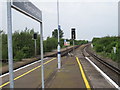
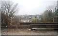
Folkestone Central railway station, Kent
View west towards Folkestone West station, which can just be seen in the distance.
Image: © Nigel Thompson
Taken: 29 May 2010
0.07 miles
7
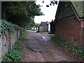
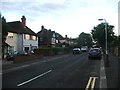
Garage access for houses on Beachborough Road
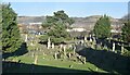
The wall on the left marks the western end of the large cemetery on Cheriton Road.
Image: © Nick Smith
Taken: 14 Oct 2009
0.08 miles