IMAGES TAKEN NEAR TO
Turketel Road, FOLKESTONE, CT20 2PA
Introduction
This page details the photographs taken nearby to Turketel Road, CT20 2PA by members of the Geograph project.
The Geograph project started in 2005 with the aim of publishing, organising and preserving representative images for every square kilometre of Great Britain, Ireland and the Isle of Man.

There are currently over 7.5m images from over14,400 individuals and you can help contribute to the project by visiting https://www.geograph.org.uk
Image Map
Images are licensed for reuse under creativecommons.org/licenses/by-sa/2.0
Notes
- Clicking on the map will re-center to the selected point.
- The higher the marker number, the further away the image location is from the centre of the postcode.
Image Listing (28 Images Found)
Images are licensed for reuse under creativecommons.org/licenses/by-sa/2.0
Image
Details
Distance
1
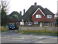
77, Shorncliffe Road
Planning permission has been approved, with conditions, by Folkestone and Hythe District Council under application number Y19/1268/FH for a “single storey rear extension, garage conversion & new driveway”.
Image: © John Baker
Taken: 1 Mar 2020
0.11 miles
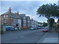
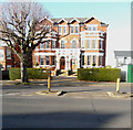
2
74 & 76, Shorncliffe Road
Planning permission has been approved, with conditions, by Folkestone and Hythe District Council under application number Y15/0565/SH as the “change of use and conversion of to four self-contained flats, including ancillary demolition of existing extensions.” This application relates to number 74.
Planning permission has been approved, with conditions, by Folkestone and Hythe District Council under application number Y15/0564/SH for the “change of use and conversion to a mixed use of chapel and community use, living accommodation for religious order, with guest accommodation, and construction of a detached single storey building for use as a pre-school for a maximum of 20 children, together with creation of two self-contained flats and the demolition of existing extensions, erection of fire escape, fenestration changes, erection of 1.8m high mesh fencing”. This application relates to number 76, which is to the left of number 74.
Image: © John Baker
Taken: 10 Dec 2015
0.13 miles
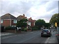
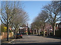
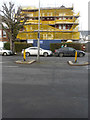
4
Lyn Court, Shorncliffe Road
The scaffolding that has been erected, on parts of the frontage of the building, indicates that alterations are being made to it. Note: the boarded up windows on the left side of the building.
Image: © John Baker
Taken: 10 Dec 2015
0.14 miles
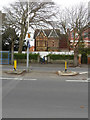
6
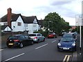
Grimston Avenue
At junction with Shorncliffe Road.
Image: © Oast House Archive
Taken: 8 Apr 2010
0.16 miles
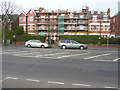
8
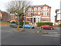
58 - 60 & 62, Shorncliffe Road
Planning permission has been approved, with conditions, by Folkestone and Hythe District Council under application number Y14/1149/SH for the “proposed residential development of 42 flats arranged in three separate four-storey buildings, following the demolition of the existing structures and including the creation of associated vehicular accesses”. Number 62 is the house to the left of the semi-detached house, which is numbered 58 and 60.
Image: © John Baker
Taken: 10 Dec 2015
0.17 miles
9
58-60, Shorncliffe Road
This was Image in January 2018. Note how the lamppost has been removed since that date.
Image: © John Baker
Taken: 1 Mar 2020
0.17 miles
10
58-60, Shorncliffe Road
Planning permission was approved, with conditions, by Folkestone and Hythe District Council under application number Y17/0684/SH for the “change of use and conversion from former school building to eight flats, with minor external alterations and associated vehicle parking".
Image: © John Baker
Taken: 4 Jan 2018
0.18 miles