IMAGES TAKEN NEAR TO
Martello Road, FOLKESTONE, CT20 1PT
Introduction
This page details the photographs taken nearby to Martello Road, CT20 1PT by members of the Geograph project.
The Geograph project started in 2005 with the aim of publishing, organising and preserving representative images for every square kilometre of Great Britain, Ireland and the Isle of Man.

There are currently over 7.5m images from over14,400 individuals and you can help contribute to the project by visiting https://www.geograph.org.uk
Image Map
Images are licensed for reuse under creativecommons.org/licenses/by-sa/2.0
Notes
- Clicking on the map will re-center to the selected point.
- The higher the marker number, the further away the image location is from the centre of the postcode.
Image Listing (179 Images Found)
Images are licensed for reuse under creativecommons.org/licenses/by-sa/2.0
Image
Details
Distance
1
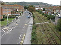
View from Radnor Bridge Road along old railway line
The road is The Tram Road and both road and disused railway lead down to the harbour.
Image: © Nick Smith
Taken: 14 Oct 2009
0.04 miles
2
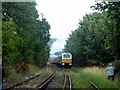
Folkestone - 2007
Folkestone, The Tram Road, Harbour Branch Railway Line, Footpath level crossing. Venice-Simplon Orient Express, British Pullmann Carriages, EWS Company Class 67 Locomotive No. 67029.
Image: © Helmut Zozmann
Taken: 28 Jul 2007
0.04 miles
3
Folkestone - 2007
Folkestone, The Tram Road, Harbour Branch Railway Line, Footpath level crossing. Venice-Simplon Orient Express, British Pullman Carriages, EWS Company Class 67 Locomotive No. 67029.
Image: © Helmut Zozmann
Taken: 28 Jul 2007
0.04 miles
7
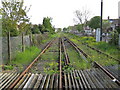
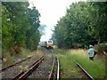
Disused Railway line in Folkestone (2)
This unused railway line used to lead from the main Dover-Folkestone line. It then branched off, headed over Warren Road (with disused level crossing), then heads under Radnor Bridge Road (just seen in background), then past the Harbour, to end on Folkestone Harbour Pier.
Image: © David Anstiss
Taken: 2 May 2009
0.07 miles
10
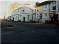
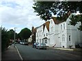
Former Martello Hotel, 108, Dover Road
A board, attached to the building, bears the information that it is to be sold, at auction, as a freehold investment by Savills http://www.savills.co.uk/
Its former name was the Fleur de Lis Inn, from where a coach service operated, c.1800, taking passengers to Dover, Deal and Canterbury. The name was changed to Martello Hotel in about 1856, after it was rebuilt, to commemorate the series of small forts, the Martello Towers, between Folkestone and Romney Marsh, built to defend the coast in the event of invasion by Napoleon http://www.dover-kent.com/Martello-Hotel-Folkestone.html
Image: © John Baker
Taken: 7 Jan 2016
0.07 miles