IMAGES TAKEN NEAR TO
Dover Road, FOLKESTONE, CT20 1JJ
Introduction
This page details the photographs taken nearby to Dover Road, CT20 1JJ by members of the Geograph project.
The Geograph project started in 2005 with the aim of publishing, organising and preserving representative images for every square kilometre of Great Britain, Ireland and the Isle of Man.

There are currently over 7.5m images from over14,400 individuals and you can help contribute to the project by visiting https://www.geograph.org.uk
Image Map
Images are licensed for reuse under creativecommons.org/licenses/by-sa/2.0
Notes
- Clicking on the map will re-center to the selected point.
- The higher the marker number, the further away the image location is from the centre of the postcode.
Image Listing (646 Images Found)
Images are licensed for reuse under creativecommons.org/licenses/by-sa/2.0
Image
Details
Distance
1
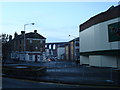
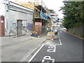
Dover Road and Bradstone Road, Folkestone
Image: © Stacey Harris
Taken: 16 Feb 2010
0.01 miles
2

Conversion of 1, Dover Road
Planning permission has been approved, with conditions, by Folkestone and Hythe District Council under application number Y15/0631/SH for a “change of use and conversion of Funeral Directors into 10 self-contained flats together with external alterations”. This is part of the Image, seen from Bradstone Road. It was the Image
Image: © John Baker
Taken: 17 Jul 2016
0.01 miles
3
Souni Court, Bradstone Road
Souni Court is comprised of 10 self-contained flats. Seen here during the Image, the entrance to this building is now in Bradstone Road, because the former has been bricked up.
Image: © John Baker
Taken: 20 Nov 2016
0.01 miles
4
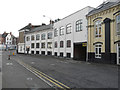
Souni Court, Bradstone Road
Souni Court is comprised of 10 self-contained flats. Seen here during the Image, the entrance to this building is now in Bradstone Road.
Image: © John Baker
Taken: 20 Nov 2016
0.01 miles
5

Conversion of 1, Dover Road
Planning permission has been approved, with conditions, by Folkestone and Hythe District Council under application number Y15/0631/SH: for a “change of use and conversion of Funeral Directors into 10 self-contained flats together with external alterations”. Seen from Bradstone Road this is part of the Image
Image: © John Baker
Taken: 17 Jul 2016
0.01 miles
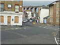
6
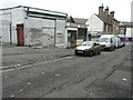
Derelict businesses along Foord Road South
Image: © John Baker
Taken: 2 Mar 2014
0.01 miles
7
Foord Road South
Planning permission has been approved, with conditions, by Folkestone and Hythe District Council under application number Y18/0446/SH for the “erection of a three storey extension to 'Solini Court' (1 Dover Road) to create 4 self-contained flats ( 2 x 1-bedroom, 2 x 2-bedroom) together with a shared cycle store and bin storage for 6 Foord Road South and Solini Court”.
The flats, under construction, are being erected on the site of some of the Image
Image: © John Baker
Taken: 14 Jul 2019
0.01 miles
8
Folkestone - 2014
Folkestone, Kent, Dover Road, Bradstone Road, Foord Railway Viaduct visible in the distance
Image: © Helmut Zozmann
Taken: 4 Oct 2014
0.02 miles
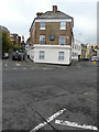
9
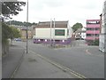
Seven Bingo (formerly Deluxe), 28-30 Dover Road
This building was built for the Co-op in 1923 before it became a venue for playing bingo, although from this side the name displayed is Deluxe Clubs http://playingbingo.co.uk/land-bingo/club-finder/f/folkestone-seven-bingo-dover-road.php
Image: © John Baker
Taken: 25 Aug 2013
0.02 miles
10
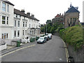
Looking east-southeast along Foord Road South
To where scaffolding has been erected along the back of Folkestone Library, whose entrance is on Grace Hill.
Image: © John Baker
Taken: 8 Jul 2016
0.02 miles