IMAGES TAKEN NEAR TO
Clarence Street, FOLKESTONE, CT20 1HT
Introduction
This page details the photographs taken nearby to Clarence Street, CT20 1HT by members of the Geograph project.
The Geograph project started in 2005 with the aim of publishing, organising and preserving representative images for every square kilometre of Great Britain, Ireland and the Isle of Man.

There are currently over 7.5m images from over14,400 individuals and you can help contribute to the project by visiting https://www.geograph.org.uk
Image Map
Images are licensed for reuse under creativecommons.org/licenses/by-sa/2.0
Notes
- Clicking on the map will re-center to the selected point.
- The higher the marker number, the further away the image location is from the centre of the postcode.
Image Listing (578 Images Found)
Images are licensed for reuse under creativecommons.org/licenses/by-sa/2.0
Image
Details
Distance
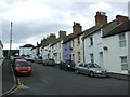
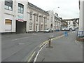
4
Dover Road
The premises to the right of the lamppost is Bar Luxor, while the premises to the left of the lamppost are derelict, the further being number 85.
Image: © John Baker
Taken: 25 Aug 2013
0.03 miles
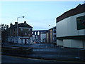
5
Demolition site, Dover Road
Folkestone and Hythe District Council did not raise an objection under application number Y14/1173/SH for the “prior notification of proposed demolition of 28-38 Dover Road and 83-85 Tontine Street”. This is Image as it was before demolition started.
Image: © John Baker
Taken: 2 Jun 2015
0.03 miles
6
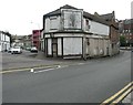
85, Dover Road
Standing on the corner of Tontine Street (to the left) and Dover Road (to the right),it appears very worse for wear.
Image: © John Baker
Taken: 25 Aug 2013
0.03 miles
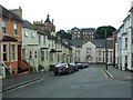
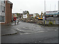
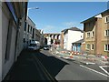
7
Dover Road and Bradstone Road, Folkestone
Image: © Stacey Harris
Taken: 16 Feb 2010
0.03 miles
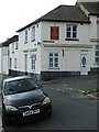
8
Bradstone Road
On the left is the sign for Skiddy’s, which is a dealer in part-worn tyres. Channel House is beyond and was formerly the Salvation Army Citadel, which was put up for sale in 2002. The organisation moved to Image, which was opened in 2002 on the site of the demolished Blue Star Garage,
Image: © John Baker
Taken: 20 Sep 2013
0.03 miles
9
New Street, Folkestone
Laying of a new gas main. In the distance, houses along Bradstone Road with the railway viaduct over Foord Road beyond.
Image: © John Baker
Taken: 24 Aug 2012
0.03 miles
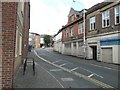
10

Conversion of 1, Dover Road
Planning permission has been approved, with conditions, by Folkestone and Hythe District Council under application number Y15/0631/SH: for a “change of use and conversion of Funeral Directors into 10 self-contained flats together with external alterations”. Seen from Bradstone Road this is part of the Image
Image: © John Baker
Taken: 17 Jul 2016
0.03 miles