IMAGES TAKEN NEAR TO
Lawrence Court, Dover Road, FOLKESTONE, CT19 6QT
Introduction
This page details the photographs taken nearby to Lawrence Court, Dover Road, CT19 6QT by members of the Geograph project.
The Geograph project started in 2005 with the aim of publishing, organising and preserving representative images for every square kilometre of Great Britain, Ireland and the Isle of Man.

There are currently over 7.5m images from over14,400 individuals and you can help contribute to the project by visiting https://www.geograph.org.uk
Image Map
Images are licensed for reuse under creativecommons.org/licenses/by-sa/2.0
Notes
- Clicking on the map will re-center to the selected point.
- The higher the marker number, the further away the image location is from the centre of the postcode.
Image Listing (62 Images Found)
Images are licensed for reuse under creativecommons.org/licenses/by-sa/2.0
Image
Details
Distance
1
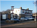
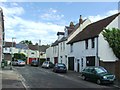
The Railway Bell Pub, Folkestone
Closed pub on junction of Alexandra Street (on left) and A260 Dover Road (in front).
Image: © David Anstiss
Taken: 31 Jan 2009
0.04 miles
7
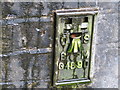
Ordnance Survey Flush Bracket G4890
This can be found on the parapet wall beside the A260.
For more detail see : http://www.bench-marks.org.uk/bm13890
Image: © Peter Wood
Taken: 15 Feb 2016
0.10 miles