IMAGES TAKEN NEAR TO
Holywell Avenue, FOLKESTONE, CT19 6JY
Introduction
This page details the photographs taken nearby to Holywell Avenue, CT19 6JY by members of the Geograph project.
The Geograph project started in 2005 with the aim of publishing, organising and preserving representative images for every square kilometre of Great Britain, Ireland and the Isle of Man.

There are currently over 7.5m images from over14,400 individuals and you can help contribute to the project by visiting https://www.geograph.org.uk
Image Map
Images are licensed for reuse under creativecommons.org/licenses/by-sa/2.0
Notes
- Clicking on the map will re-center to the selected point.
- The higher the marker number, the further away the image location is from the centre of the postcode.
Image Listing (26 Images Found)
Images are licensed for reuse under creativecommons.org/licenses/by-sa/2.0
Image
Details
Distance
6
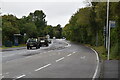
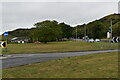
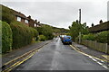
Folkestone - 2008
Folkestone, Canterbury Road, A260.
Image: © Helmut Zozmann
Taken: 4 Jul 2008
0.13 miles
7
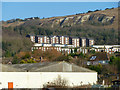
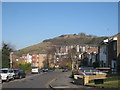
Flats on Sugarloaf Hill
Housing built high above Folkestone.
Image: © Robin Webster
Taken: 16 Jan 2013
0.14 miles
9
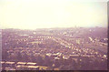
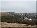
View over Folkestone in 1973
From the top of Sugarloaf Hill. Dolphins Road snakes from left to right in the middle distance while further towards the sea is the Foord viaduct carrying the railway from Folkestone to Dover
Image: © John Baker
Taken: 30 Jun 1973
0.15 miles