IMAGES TAKEN NEAR TO
Holly Close, FOLKESTONE, CT19 6JQ
Introduction
This page details the photographs taken nearby to Holly Close, CT19 6JQ by members of the Geograph project.
The Geograph project started in 2005 with the aim of publishing, organising and preserving representative images for every square kilometre of Great Britain, Ireland and the Isle of Man.

There are currently over 7.5m images from over14,400 individuals and you can help contribute to the project by visiting https://www.geograph.org.uk
Image Map
Images are licensed for reuse under creativecommons.org/licenses/by-sa/2.0
Notes
- Clicking on the map will re-center to the selected point.
- The higher the marker number, the further away the image location is from the centre of the postcode.
Image Listing (40 Images Found)
Images are licensed for reuse under creativecommons.org/licenses/by-sa/2.0
Image
Details
Distance
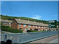
1
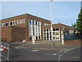
Wood Avenue Library
This library is on the junction of Wood Avenue (on the right) and Beatty Road (on the left).
Image: © David Anstiss
Taken: 2 May 2009
0.08 miles
2
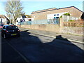
Wood Avenue Library
The entrance to Image
2022 opening times for the library were as follows:
Sunday: closed
Monday: 10.00 am – 1.00pm, 2.00pm – 4.30pm
Tuesday: closed
Wednesday: 9:30 – 1.00pm
Thursday: 10.00am – 1.00pm, 2.00 pm – 4.30 pm
Friday: 10.00am – 1.00pm, 2.00 pm – 4.30 pm
Saturday: 10.00am – 1.00pm
Image: © John Baker
Taken: 12 Jan 2022
0.09 miles
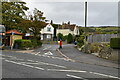
3
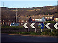
Roundabout on A260
Houses on Fleming Way, and Creteway Down hills to rear.
Image: © Oast House Archive
Taken: 25 Nov 2009
0.12 miles
5
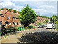
Folkestone - 2008
Folkestone, Hill Road, A260.
Image: © Helmut Zozmann
Taken: 4 Jul 2008
0.13 miles
7
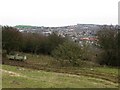
View across Folkestone rooftops from Creteway Down 3
Folkestone harbour wall can be seen in the top of the photo.
Image: © Nick Smith
Taken: 15 Feb 2009
0.13 miles
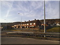
10
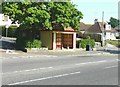
Wood Avenue bus shelter, Folkestone
The Wood Avenue shelter, which was built in 1927, was the original terminus of the old East Kent Bus Company and marked the boundary of the Folkestone area. During the summer of 2011, when there were fears that the shelter might be demolished, members of the Wood Avenue, Park View and Kitchener Square Community Association set out to save and restore it. Permission was given by Shepway District Council to carry out repairs, a restoration plan was put together and funds were raised by The Association. In its restored condition, the shelter sports the colours of the Folkestone buses of the 1920s in cream and maroon (taken from Shepway Today, Spring/Summer 2012).
Image: © John Baker
Taken: 27 May 2012
0.14 miles