IMAGES TAKEN NEAR TO
Ethelbert Road, FOLKESTONE, CT19 6EX
Introduction
This page details the photographs taken nearby to Ethelbert Road, CT19 6EX by members of the Geograph project.
The Geograph project started in 2005 with the aim of publishing, organising and preserving representative images for every square kilometre of Great Britain, Ireland and the Isle of Man.

There are currently over 7.5m images from over14,400 individuals and you can help contribute to the project by visiting https://www.geograph.org.uk
Image Map
Images are licensed for reuse under creativecommons.org/licenses/by-sa/2.0
Notes
- Clicking on the map will re-center to the selected point.
- The higher the marker number, the further away the image location is from the centre of the postcode.
Image Listing (66 Images Found)
Images are licensed for reuse under creativecommons.org/licenses/by-sa/2.0
Image
Details
Distance
8
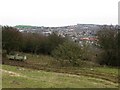
View across Folkestone rooftops from Creteway Down 3
Folkestone harbour wall can be seen in the top of the photo.
Image: © Nick Smith
Taken: 15 Feb 2009
0.06 miles
10
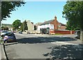
Papa's Fish and Chips, Canterbury Road, Folkestone
This is a newly opened enterprise that was formerly Image and has been beautifully transformed. There is another premises at 110 Sandgate Road, Folkestone, which is just beyond Image
Image: © John Baker
Taken: 27 May 2012
0.07 miles