IMAGES TAKEN NEAR TO
The Durlocks, FOLKESTONE, CT19 6AW
Introduction
This page details the photographs taken nearby to The Durlocks, CT19 6AW by members of the Geograph project.
The Geograph project started in 2005 with the aim of publishing, organising and preserving representative images for every square kilometre of Great Britain, Ireland and the Isle of Man.

There are currently over 7.5m images from over14,400 individuals and you can help contribute to the project by visiting https://www.geograph.org.uk
Image Map
Images are licensed for reuse under creativecommons.org/licenses/by-sa/2.0
Notes
- Clicking on the map will re-center to the selected point.
- The higher the marker number, the further away the image location is from the centre of the postcode.
Image Listing (952 Images Found)
Images are licensed for reuse under creativecommons.org/licenses/by-sa/2.0
Image
Details
Distance
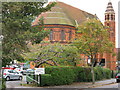
1
Folkestone, The Durlocks
Folkestone, The Durlocks, St Andrew's
Image: © Helmut Zozmann
Taken: 20 Jul 2011
0.01 miles
2
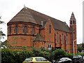
Folkestone, The Durlocks
Folkestone, The Durlocks, St Andrew's
Image: © Helmut Zozmann
Taken: 20 Jul 2011
0.01 miles
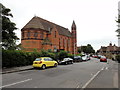
4
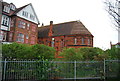
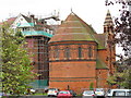
St Andrew's Chapel
Grade II listed. http://www.britishlistedbuildings.co.uk/en-175325-st-andrews-hotel-and-chapel-folkestone-k
Image: © N Chadwick
Taken: 12 Apr 2014
0.01 miles
5
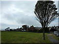
View across the green from Wear Bay Road, Folkestone
The red brick building was St. Andrew's Church and is now converted into private dwellings. To the left is St. Peter's Church and to the left of that is the Grand Burstin hotel on Harbour Approach Road.
Image: © pam fray
Taken: 20 Aug 2012
0.02 miles
6
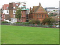
St Andrew's church from East Cliff Triangle
Image: © Nick Smith
Taken: 14 Oct 2009
0.03 miles
7
St Andrew's, The Durlocks, Folkestone
I don't know if this is still a church, a sign on the car park simply says "St Andrews, private car park, residents only" so possibly just residential?
Image: © Nick Smith
Taken: 14 Oct 2009
0.03 miles
8
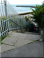
East Cliff steps
A useful flight of very, steep steps for gaining access to The Stade from an area of grass beside Wear Bay Road.
Image: © John Baker
Taken: 31 Jul 2016
0.03 miles