IMAGES TAKEN NEAR TO
Archer Road, FOLKESTONE, CT19 5SA
Introduction
This page details the photographs taken nearby to Archer Road, CT19 5SA by members of the Geograph project.
The Geograph project started in 2005 with the aim of publishing, organising and preserving representative images for every square kilometre of Great Britain, Ireland and the Isle of Man.

There are currently over 7.5m images from over14,400 individuals and you can help contribute to the project by visiting https://www.geograph.org.uk
Image Map
Images are licensed for reuse under creativecommons.org/licenses/by-sa/2.0
Notes
- Clicking on the map will re-center to the selected point.
- The higher the marker number, the further away the image location is from the centre of the postcode.
Image Listing (141 Images Found)
Images are licensed for reuse under creativecommons.org/licenses/by-sa/2.0
Image
Details
Distance
3

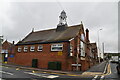
The Salvation Army Citadel, Folkestone
On junction of Canterbury Road (on left) and Archer Road (on right).
Image: © David Anstiss
Taken: 31 Jan 2009
0.10 miles
9
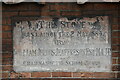
Foundation Stone, Mundelia Primary School
Image: © N Chadwick
Taken: 11 Sep 2019
0.12 miles
10
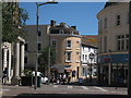
Folkestone Shopping Area
Centre building at junction of Rendezvous Street and Church Street.
Image: © Oast House Archive
Taken: 29 May 2009
0.12 miles