IMAGES TAKEN NEAR TO
The Waltons, Downs Road, FOLKESTONE, CT19 5QF
Introduction
This page details the photographs taken nearby to The Waltons, Downs Road, CT19 5QF by members of the Geograph project.
The Geograph project started in 2005 with the aim of publishing, organising and preserving representative images for every square kilometre of Great Britain, Ireland and the Isle of Man.

There are currently over 7.5m images from over14,400 individuals and you can help contribute to the project by visiting https://www.geograph.org.uk
Image Map
Images are licensed for reuse under creativecommons.org/licenses/by-sa/2.0
Notes
- Clicking on the map will re-center to the selected point.
- The higher the marker number, the further away the image location is from the centre of the postcode.
Image Listing (19 Images Found)
Images are licensed for reuse under creativecommons.org/licenses/by-sa/2.0
Image
Details
Distance
1

View over Folkestone in 1973
From the top of Sugarloaf Hill. Dolphins Road snakes from left to right in the middle distance while further towards the sea is the Foord viaduct carrying the railway from Folkestone to Dover
Image: © John Baker
Taken: 30 Jun 1973
0.03 miles
2

Johnsons Recycling Centre, Unit 1, Park Farm Close
The firm’s former location is now a Image
Image: © John Baker
Taken: 4 Jun 2017
0.14 miles
3

View across Folkestone rooftops from Creteway Down 2
Image: © Nick Smith
Taken: 15 Feb 2009
0.17 miles

5

Folkestone Fixings, 3b Park Farm Road
Dealing in building and timber supplies.
Image: © John Baker
Taken: 10 Nov 2013
0.17 miles
6

Looking northwest along Park Farm Road
On the left is the entrance to a site that was once occupied by Silver Spring Mineral Water Company Ltd. Planning permission was not required by Folkestone and Hythe District Council under application number Y/13/0693/SH for the “demolition of existing factory buildings (28 demolition notice)”.
Image: © John Baker
Taken: 10 Nov 2013
0.17 miles
7

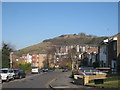
Flats on Sugarloaf Hill
Housing built high above Folkestone.
Image: © Robin Webster
Taken: 16 Jan 2013
0.19 miles
8

Entrance to the former Silver Spring Mineral Water Company's site
Planning permission was not required by Folkestone and Hythe District Council under application number Y/13/0693/SH for the “demolition of existing factory buildings (28 demolition notice)”. The company was located in Park Farm Road.
Image: © John Baker
Taken: 10 Nov 2013
0.19 miles
9
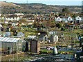
Park Farm Road Allotments
Viewed from Park Farm Road.
Image: © Robin Webster
Taken: 16 Jan 2013
0.20 miles