IMAGES TAKEN NEAR TO
Canterbury Road, FOLKESTONE, CT19 5NL
Introduction
This page details the photographs taken nearby to Canterbury Road, CT19 5NL by members of the Geograph project.
The Geograph project started in 2005 with the aim of publishing, organising and preserving representative images for every square kilometre of Great Britain, Ireland and the Isle of Man.

There are currently over 7.5m images from over14,400 individuals and you can help contribute to the project by visiting https://www.geograph.org.uk
Image Map
Images are licensed for reuse under creativecommons.org/licenses/by-sa/2.0
Notes
- Clicking on the map will re-center to the selected point.
- The higher the marker number, the further away the image location is from the centre of the postcode.
Image Listing (82 Images Found)
Images are licensed for reuse under creativecommons.org/licenses/by-sa/2.0
Image
Details
Distance
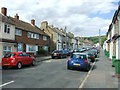
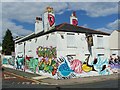
4
Folkestone, Canterbury Road
Folkestone, 80 Canterbury Road, Twin Dragon Chinese Take-Away, CT19 5NN.
Image: © Helmut Zozmann
Taken: 20 Jul 2011
0.03 miles
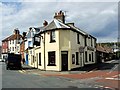
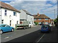
5

The Royal Standard Pub, Folkestone
On the junction of 60 Canterbury Street (in front) and Bridge Street (on right).
The Two Bells - closed pub is other side of Bridge Street.
Image: © David Anstiss
Taken: 31 Jan 2009
0.03 miles
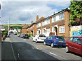
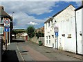
6
Folkestone, Canterbury Road
Folkestone, Salvation Army, 75-77 Canterbury Road, CT19 5NL seen from Archer Street
Image: © Helmut Zozmann
Taken: 20 Jul 2011
0.03 miles
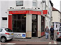
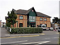
10

The Salvation Army Citadel, Folkestone
On junction of Canterbury Road (on left) and Archer Road (on right).
Image: © David Anstiss
Taken: 31 Jan 2009
0.04 miles