IMAGES TAKEN NEAR TO
Cherry Garden Avenue, FOLKESTONE, CT19 5LE
Introduction
This page details the photographs taken nearby to Cherry Garden Avenue, CT19 5LE by members of the Geograph project.
The Geograph project started in 2005 with the aim of publishing, organising and preserving representative images for every square kilometre of Great Britain, Ireland and the Isle of Man.

There are currently over 7.5m images from over14,400 individuals and you can help contribute to the project by visiting https://www.geograph.org.uk
Image Map
Images are licensed for reuse under creativecommons.org/licenses/by-sa/2.0
Notes
- Clicking on the map will re-center to the selected point.
- The higher the marker number, the further away the image location is from the centre of the postcode.
Image Listing (14 Images Found)
Images are licensed for reuse under creativecommons.org/licenses/by-sa/2.0
Image
Details
Distance
1
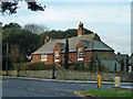
Broadmead Manor
At the corner of Cherry Garden Lane and Cherry Garden Avenue, this is considerably older than surrounding houses. It is dated 1700 on the porch.
Image: © Robin Webster
Taken: 16 Jan 2013
0.05 miles
2
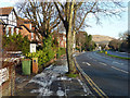
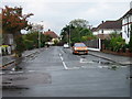
Cherry Garden Avenue
The way out of Folkestone to Junction 13 of the M20, where the motorway becomes the A20 onwards to Dover.
Image: © Robin Webster
Taken: 16 Jan 2013
0.14 miles
3
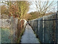
Footpath, Morehall
Morehall Primary School is to the left, a playing field to the right.
Image: © Robin Webster
Taken: 16 Jan 2013
0.19 miles
4
44, Cherry Garden Lane
Planning permission has been approved, with conditions, by Folkestone and Hythe District Council under application number Y14/0652/SH for the “erection of a side extension, loft conversion and front dormer window”. It appears that gas is being installed, perhaps to the house or along the road, as there is a large reel of gas piping in front of the house.
Image: © John Baker
Taken: 14 Feb 2015
0.19 miles
7
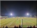
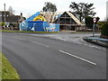
Folkestone Invicta FC
Folkestone Invicta vs Hastings United match in the Isthmian League Premier Division.
Image: © Leon Pettit
Taken: 16 Aug 2022
0.23 miles
8
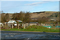
Tile Kiln Lane allotments
Sandwiched between residential and industrial areas on the northern fringe of the Folkestone built-up area.
Image: © Robin Webster
Taken: 16 Jan 2013
0.23 miles
9
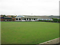
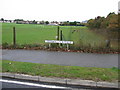
Folkestone bowls club, outdoor green
A thriving club http://www.folkestonebowls.co.uk/
Image: © Nick Smith
Taken: 14 Oct 2009
0.23 miles
10
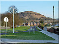
Cherry Garden Lane on a frosty morning
This road loops round to start and finish on Cherry Garden Avenue. It is surprising the name is continuous though two angled junctions, probably the result of superimposing urban roads on a previously rural area. Castle Hill looms in the distance.
Image: © Robin Webster
Taken: 16 Jan 2013
0.24 miles