IMAGES TAKEN NEAR TO
West Park Farm North Retail Park, Park Farm Road, FOLKESTONE, CT19 5FF
Introduction
This page details the photographs taken nearby to West Park Farm North Retail Park, Park Farm Road, CT19 5FF by members of the Geograph project.
The Geograph project started in 2005 with the aim of publishing, organising and preserving representative images for every square kilometre of Great Britain, Ireland and the Isle of Man.

There are currently over 7.5m images from over14,400 individuals and you can help contribute to the project by visiting https://www.geograph.org.uk
Image Map
Images are licensed for reuse under creativecommons.org/licenses/by-sa/2.0
Notes
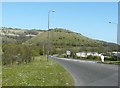
- Clicking on the map will re-center to the selected point.
- The higher the marker number, the further away the image location is from the centre of the postcode.
Image Listing (49 Images Found)
Images are licensed for reuse under creativecommons.org/licenses/by-sa/2.0
Image
Details
Distance
1
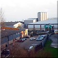
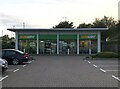
Retail Park at Park Farm Road
Pets at Home to the rear, the largest chain of pet shops in the UK.
Image: © Oast House Archive
Taken: 25 Nov 2009
0.03 miles
2
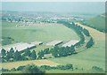
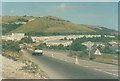
West Park Farm Industrial Site in 1973
The road curving into the distance is Churchill Avenue. The southern slope of Castle Hill can be seen on the right. The view was taken from the top of Sugarloaf Hill. See http://www.geograph.org.uk/photo/1732647
Image: © John Baker
Taken: 30 Jun 1973
0.03 miles
3
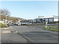
Park Farm West, Folkestone
On the corner of Kingsmead (the road to the right) is the Comet warehouse, that closed just before Christmas 2012.
Image: © John Baker
Taken: 27 Jan 2013
0.04 miles
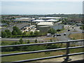
4
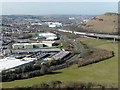
West Park Farm North Retail Park
Castle Hill lies on the right hand side of this view which was taken from the top of Sugarloaf Hill. The A20 runs along its base while beyond it is the marshalling yard of the Channel Tunnel shuttle service. In the foreground, Churchill Avenue curves round the buildings of the retail park, which includes stores such as Sainsbury's, Homebase, Currys and Comet. See http://www.geograph.org.uk/photo/1732607 for view taken in 1973.
Image: © John Baker
Taken: 2 Mar 2010
0.05 miles
5
'Subway' sandwich outlet
'Subway' outlet at West Park Farm North Retail Park.
Image: © David Robinson
Taken: 1 Sep 2023
0.05 miles
6
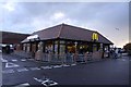
McDonald's restaurant on Park Farm Industrial Estate
Image: © Steve Daniels
Taken: 13 Oct 2012
0.07 miles
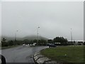
7
Churchill Avenue and roundabout seen from the A20
Image: © Colin Pyle
Taken: 13 May 2011
0.08 miles
8
Folkestone, Round Hill
Folkestone, Round Hill, seen from Churchill Avenue, A259.
Image: © Helmut Zozmann
Taken: 4 Aug 2011
0.09 miles
9
Churchill Avenue, Folkestone
The road runs beneath Sugarloaf Hill and to the north of West Park Farm North Retail Park (part of which can be seen in this picture)
Image: © John Baker
Taken: 25 Apr 2010
0.09 miles
10
Churchill Avenue, Folkestone in 1988
This view was taken during the building of the Channel Tunnel and the nearby Shuttle terminus and shows portacabins nestling beneath Sugarloaf Hill. Nowadays more lamp posts have been added to illuminate the road and the scars on the landscape have healed see http://www.geograph.org.uk/photo/1828060
Image: © John Baker
Taken: 13 Aug 1988
0.09 miles