IMAGES TAKEN NEAR TO
Downside, FOLKESTONE, CT19 5DG
Introduction
This page details the photographs taken nearby to Downside, CT19 5DG by members of the Geograph project.
The Geograph project started in 2005 with the aim of publishing, organising and preserving representative images for every square kilometre of Great Britain, Ireland and the Isle of Man.

There are currently over 7.5m images from over14,400 individuals and you can help contribute to the project by visiting https://www.geograph.org.uk
Image Map
Images are licensed for reuse under creativecommons.org/licenses/by-sa/2.0
Notes
- Clicking on the map will re-center to the selected point.
- The higher the marker number, the further away the image location is from the centre of the postcode.
Image Listing (18 Images Found)
Images are licensed for reuse under creativecommons.org/licenses/by-sa/2.0
Image
Details
Distance
1
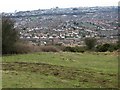
View across Folkestone rooftops from Creteway Down 1
Image: © Nick Smith
Taken: 15 Feb 2009
0.07 miles
2
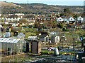
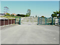
Park Farm Road Allotments
Viewed from Park Farm Road.
Image: © Robin Webster
Taken: 16 Jan 2013
0.09 miles
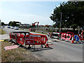
3
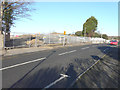
Building site, Park Farm Road
Planning permission has been approved, with conditions, by Folkestone and Hythe District Council under application number Y11/1132/SH for an “outline application for the construction of 130 dwellings (Class C3) following the demolition of the Folkestone Primary Academy (formerly Park Farm Primary School) inclusive of details, layout and scale”.
Image: © John Baker
Taken: 29 Jan 2015
0.10 miles
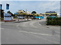
4
Scholars Village, Park Farm Road
Compared with Image, houses have now been/are being erected on the site.
Image: © John Baker
Taken: 3 Jul 2015
0.10 miles
5
Development site, Moat Farm Road
Planning permission has been approved, with conditions, by Folkestone and Hythe District Council under application number Y19/0704/FH for the “erection of 30 residential units with access road, footpaths and associated landscaping”.
The site used to be the location of Highview School.
Image: © John Baker
Taken: 8 May 2022
0.11 miles
6
Entrance to Scholars Village, Park Farm Road
Planning permission has been approved, with conditions, by Folkestone and Hythe District Council under application number Y11/1132/SH for the “outline application for the construction of 130 dwellings (Class C3) following the demolition of the Folkestone Primary Academy (formerly Park Farm Primary School) inclusive of details, layout and scale”.
Image: © John Baker
Taken: 3 Jul 2015
0.12 miles
7

Entrance to special education needs school site, Park Farm Road
Planning permission was not required by Folkestone and Hythe District Council under application number Y14/0711/SH for a “consultation in respect of a new two-storey Special Education Needs School with associated car parking and landscaping”. The location was “land at former Channel High School, Park Farm Road“.
Image: © John Baker
Taken: 3 Jul 2015
0.12 miles
8
Erection of a special education needs school, Park Farm Road
Planning permission was not required by Folkestone and Hythe District Council under application number Y14/0711/SH for a “consultation in respect of a new two-storey Special Education Needs School with associated car parking and landscaping”. The location was “land at former Channel High School, Park Farm Road“.
Image: © John Baker
Taken: 3 Jul 2015
0.14 miles
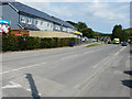
9
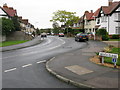
Looking E along Alder Road from Beech Close
Image: © Nick Smith
Taken: 14 Oct 2009
0.21 miles
10
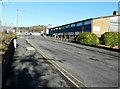
Folkestone Fixings, 3b Park Farm Road
Dealing in building and timber supplies.
Image: © John Baker
Taken: 10 Nov 2013
0.21 miles