IMAGES TAKEN NEAR TO
Stoddart Road, FOLKESTONE, CT19 4PP
Introduction
This page details the photographs taken nearby to Stoddart Road, CT19 4PP by members of the Geograph project.
The Geograph project started in 2005 with the aim of publishing, organising and preserving representative images for every square kilometre of Great Britain, Ireland and the Isle of Man.

There are currently over 7.5m images from over14,400 individuals and you can help contribute to the project by visiting https://www.geograph.org.uk
Image Map
Images are licensed for reuse under creativecommons.org/licenses/by-sa/2.0
Notes
- Clicking on the map will re-center to the selected point.
- The higher the marker number, the further away the image location is from the centre of the postcode.
Image Listing (44 Images Found)
Images are licensed for reuse under creativecommons.org/licenses/by-sa/2.0
Image
Details
Distance
1
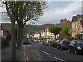
Ashley Avenue
A row of Victorian terraced houses.
Image: © Oast House Archive
Taken: 7 May 2010
0.06 miles

3
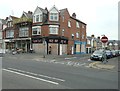
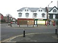
Two boarded up shops in Cheriton
Cheriton Sweet Shop stands on the corner of the High Street (A20) and Grange Road, while Scrapbook Friends (an art and craft suppliers) stands next door in Grange Road.
Image: © John Baker
Taken: 6 Sep 2013
0.12 miles
4
Emory Place, Ashley Avenue
Planning permission has been approved, with conditions, by Folkestone and Hythe District Council under application number Y16/0747/SH for the “erection of nine houses together with associated parking, turning and landscaping, following demolition of the existing building”.
The houses are being built on the site of the Image
Image: © John Baker
Taken: 10 Apr 2019
0.12 miles
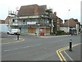
5
Cherry Pickers, Ashley Avenue
The derelict public house was damaged by fire on 25 May 2014
http://www.kentonline.co.uk/folkestone/news/breaking-news-fire-at-derelict-17746
Image: © John Baker
Taken: 2 Dec 2014
0.13 miles
6
New premises, Cheriton High Street (A20)
On 6 September 2013, scaffolding shrouded the Image but now it is only a matter of time before the premises are open for business.
Image: © John Baker
Taken: 12 Jan 2014
0.13 miles
7
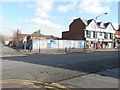
Derelict site, Cheriton High Street (A20)
On the corner of Ashley Avenue. Planning permission has been approved, with conditions, by Folkestone and Hythe District Council under application number Y12/0265/SH for the "erection of a two storey building for use as two retail units (class A1 & A2) with storage above together with rear service yard and refuse area". The site is described as “land adjoining 38 Cheriton High Street” (38-40 Cheriton High Street is the address for the post office).
Image: © John Baker
Taken: 20 Feb 2013
0.13 miles
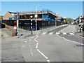
8
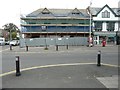
Building under construction, Cheriton High Street (A20)
When I photographed the location previously it appeared as a Image Planning permission has been approved, with conditions, by Folkestone and Hythe District Council under application numbers Y12/0265/SH for the "erection of a two storey building for use as two retail units (class A1 & A2) with storage above together with rear service yard and refuse area and Y12/0022/NMC a "non-material change to application Y12/0265/SH [the]erection of a two storey building for use as two retail units (class A1 & A2) with storage above together with rear service yard and refuse area. The site is described as “land adjoining 38 Cheriton High Street” (38-40 Cheriton High Street is the address for the post office).
Image: © John Baker
Taken: 6 Sep 2013
0.13 miles
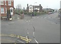
9
Cheriton, Cheriton Road
Cheriton Road looking West
Image: © Helmut Zozmann
Taken: 22 Jul 2009
0.14 miles
10
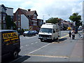
Music Bay, Cheriton
Situated on the corner of Park Road (where the van is parked) and the High Street (A20), the shop's door and windows have been boarded up, while renovation work is undertaken.
Image: © John Baker
Taken: 6 Sep 2013
0.15 miles