IMAGES TAKEN NEAR TO
Starfield Close, FOLKESTONE, CT19 4FS
Introduction
This page details the photographs taken nearby to Starfield Close, CT19 4FS by members of the Geograph project.
The Geograph project started in 2005 with the aim of publishing, organising and preserving representative images for every square kilometre of Great Britain, Ireland and the Isle of Man.

There are currently over 7.5m images from over14,400 individuals and you can help contribute to the project by visiting https://www.geograph.org.uk
Image Map
Images are licensed for reuse under creativecommons.org/licenses/by-sa/2.0
Notes
- Clicking on the map will re-center to the selected point.
- The higher the marker number, the further away the image location is from the centre of the postcode.
Image Listing (38 Images Found)
Images are licensed for reuse under creativecommons.org/licenses/by-sa/2.0
Image
Details
Distance
1
Cheriton High Street
The building under construction is being built on the site of the Brockman Family Centre. Planning permission has been approved, with conditions, by Folkestone and Hythe District Council under application number 19/1164/FH for the “demolition of existing two storey building and replacement residential development comprising of 27 Units”.
Image: © John Baker
Taken: 21 Nov 2021
0.07 miles
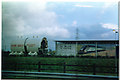
2
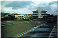
Control Centre at Cheriton
Headquarters and Control Centre for Tunnel operations.
Image: © Ron Hann
Taken: Unknown
0.08 miles
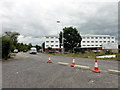
3
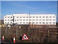
Cheriton Parc Holiday Inn
Motel on Cheriton High Street, close to Junction 12 on M20 Motorway opposite the Channel Tunnel Termnial.
See http://www.wheresbest.co.uk/venue/198373/Holiday-Inn-Express-Folkestone---Channel-Tunnel/ for more details on the motel.
Image: © David Anstiss
Taken: 30 Jan 2010
0.08 miles
4
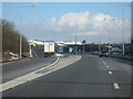
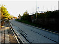
M20 Motorway, Junction 12
Exit sliproad of junction 12. One mile to junction 13 where the M20 terminates and changes into the A20 bypass.
Image: © Oast House Archive
Taken: 15 Feb 2010
0.08 miles

6
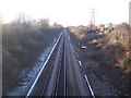
Railway from Folkestone
This line leads from Folkestone West to Sandling and Westenhanger before heading onto Ashford. Seen from Horn Street bridge. In the background on the right is Cheriton Parc Holiday Inn motel and over the railway, Cheriton High Street road Bridge.
60+ years ago, you would have seen the Elham Valley Railway joining the Ashford / Folkestone line from the right.
Image: © David Anstiss
Taken: 30 Jan 2010
0.11 miles
7
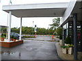
Entrance to the Holiday Inn Folkestone
Image: © Anthony Parkes
Taken: 4 Aug 2011
0.11 miles
8
Folkestone - 2015
Folkestone, Kent, Cheriton High Street, Holiday Inn Express
Image: © Helmut Zozmann
Taken: 28 Jul 2015
0.11 miles
9
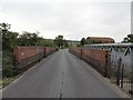
Folkestone, Horn Street
Folkestone, Horn Street railway bridge.
Image: © Helmut Zozmann
Taken: 2 Aug 2011
0.14 miles
10
Channel Tunnel Boring Machine, Cheriton
One, or is it two, of the huge machines used to bore the "hole".
Image: © Ron Hann
Taken: Unknown
0.14 miles