IMAGES TAKEN NEAR TO
Broomfield Road, FOLKESTONE, CT19 4DJ
Introduction
This page details the photographs taken nearby to Broomfield Road, CT19 4DJ by members of the Geograph project.
The Geograph project started in 2005 with the aim of publishing, organising and preserving representative images for every square kilometre of Great Britain, Ireland and the Isle of Man.

There are currently over 7.5m images from over14,400 individuals and you can help contribute to the project by visiting https://www.geograph.org.uk
Image Map
Images are licensed for reuse under creativecommons.org/licenses/by-sa/2.0
Notes
- Clicking on the map will re-center to the selected point.
- The higher the marker number, the further away the image location is from the centre of the postcode.
Image Listing (44 Images Found)
Images are licensed for reuse under creativecommons.org/licenses/by-sa/2.0
Image
Details
Distance
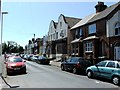
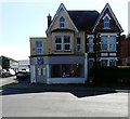
2
Looking north along Broomfield Road
On the right side of the road, the ground floor window of Music City has been boarded over.
Image: © John Baker
Taken: 1 Jun 2014
0.04 miles
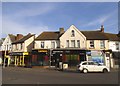
3
43, High Street
Image: © John Baker
Taken: 10 Apr 2019
0.05 miles
4
43, High Street
Planning permission was approved, with conditions, by Folkestone and Hythe District Council under application number Y15/0313/SH for the “erection of a 2 storey block of 4 flats following demolition of existing single storey rear shop floor/storage extension”. This image shows the rear of the building from Park Road. The shop was known as the Image
Image: © John Baker
Taken: 18 Jun 2017
0.05 miles
5
43, High Street
The shop is up for sale.
Image: © John Baker
Taken: 10 Apr 2019
0.05 miles
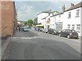
6
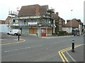
Music Bay, Cheriton
Situated on the corner of Park Road (where the van is parked) and the High Street (A20), the shop's door and windows have been boarded up, while renovation work is undertaken.
Image: © John Baker
Taken: 6 Sep 2013
0.06 miles
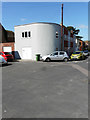
8
The Lemon Leaf Restaurant, Cheriton
Tricky Trevs Discount Store has had a coat of paint and is now a restaurant. See Google Maps from 2009.
Image: © David Howard
Taken: 10 Apr 2016
0.07 miles
9
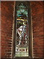
Lieut Sydney Kingston GORE, 1st Bn Royal West Kent Regiment
Memorial window in All Souls Church, Cheriton, Folkestone, erected in memory of this regular officer, who was educated at the Harvey Grammar School and at Penfilian House in Folkestone where his father was a doctor. He fell in action at the battle of Neuve Chapelle in France 28th October 1914 aged 25.
“Greater love hath no man than this, that he lay down his life for his friends”.
https://livesofthefirstworldwar.org/lifestory/1392577#timeline
Image: © D Gore
Taken: 2 Mar 2009
0.07 miles
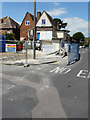
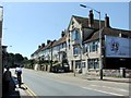
10
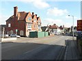
White Lion, Cheriton High Street (A20)
The cul-de-sac on the immediate left is Chilham Road. Risborough Lane (B2063) is the next road to the right. The building with the green hoarding along its front was the White Lion public house. Planning permission has been approved, with conditions, by Folkestone and Hythe District Council under application number Y07/0937/SH for the “change of use and conversion of the public house to student accommodation (Class C2) and the erection of a terrace of 4 dwellings”.
Image: © John Baker
Taken: 20 Feb 2013
0.07 miles