IMAGES TAKEN NEAR TO
Beachborough Road, FOLKESTONE, CT19 4AB
Introduction
This page details the photographs taken nearby to Beachborough Road, CT19 4AB by members of the Geograph project.
The Geograph project started in 2005 with the aim of publishing, organising and preserving representative images for every square kilometre of Great Britain, Ireland and the Isle of Man.

There are currently over 7.5m images from over14,400 individuals and you can help contribute to the project by visiting https://www.geograph.org.uk
Image Map
Images are licensed for reuse under creativecommons.org/licenses/by-sa/2.0
Notes
- Clicking on the map will re-center to the selected point.
- The higher the marker number, the further away the image location is from the centre of the postcode.
Image Listing (95 Images Found)
Images are licensed for reuse under creativecommons.org/licenses/by-sa/2.0
Image
Details
Distance
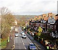
4
Junction of Cheriton Road with Cherry Garden Avenue
Image: © Nick Smith
Taken: 14 Oct 2009
0.04 miles
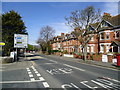
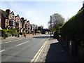
5
House on the corner of Cheriton Road
The cars are waiting at the lights.
Image: © David Howard
Taken: 10 Apr 2016
0.04 miles
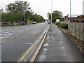
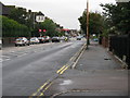
7
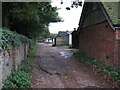
Garage access for houses on Beachborough Road
The wall on the left marks the western end of the large cemetery on Cheriton Road.
Image: © Nick Smith
Taken: 14 Oct 2009
0.05 miles
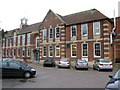
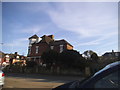
8
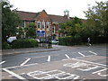
The Harvey Grammar School on Cheriton Road
Image: © Nick Smith
Taken: 14 Oct 2009
0.05 miles