IMAGES TAKEN NEAR TO
Chapel Close, FOLKESTONE, CT18 8NB
Introduction
This page details the photographs taken nearby to Chapel Close, CT18 8NB by members of the Geograph project.
The Geograph project started in 2005 with the aim of publishing, organising and preserving representative images for every square kilometre of Great Britain, Ireland and the Isle of Man.

There are currently over 7.5m images from over14,400 individuals and you can help contribute to the project by visiting https://www.geograph.org.uk
Image Map
Images are licensed for reuse under creativecommons.org/licenses/by-sa/2.0
Notes
- Clicking on the map will re-center to the selected point.
- The higher the marker number, the further away the image location is from the centre of the postcode.
Image Listing (51 Images Found)
Images are licensed for reuse under creativecommons.org/licenses/by-sa/2.0
Image
Details
Distance
2
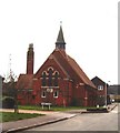
Former chapel, Etchinghill
This former chapel is now a private house and forms part of Meriden Park, a small housing development on the edge of the village.
Image: © David Kemp
Taken: 17 Mar 2007
0.02 miles
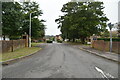
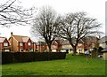
4
New houses on St Mary's Close, Etchinghill
The building in the foreground to the right is a new hall.
Image: © Nick Smith
Taken: 6 Sep 2008
0.05 miles
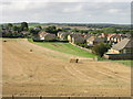
6
New housing on the S of Etchinghill
Viewed from footpath through The Beeches
Image: © Nick Smith
Taken: 6 Sep 2008
0.07 miles
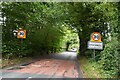
7
Meriden Park, Etchinghill
Meriden Park, a small housing development, lies just to the south of the original village.
Image: © David Kemp
Taken: 17 Mar 2007
0.08 miles