IMAGES TAKEN NEAR TO
Acrise, FOLKESTONE, CT18 8LQ
Introduction
This page details the photographs taken nearby to CT18 8LQ by members of the Geograph project.
The Geograph project started in 2005 with the aim of publishing, organising and preserving representative images for every square kilometre of Great Britain, Ireland and the Isle of Man.

There are currently over 7.5m images from over14,400 individuals and you can help contribute to the project by visiting https://www.geograph.org.uk
Image Map
Images are licensed for reuse under creativecommons.org/licenses/by-sa/2.0
Notes
- Clicking on the map will re-center to the selected point.
- The higher the marker number, the further away the image location is from the centre of the postcode.
Image Listing (12 Images Found)
Images are licensed for reuse under creativecommons.org/licenses/by-sa/2.0
Image
Details
Distance
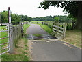
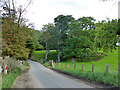
2
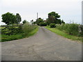
Looking E along road to Acrise Place
Taken from the junction with farm road to Mounts Court Farm
Image: © Nick Smith
Taken: 20 Jun 2008
0.11 miles
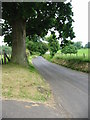
3
Mounts Court Cottage on road to Acrise Place
Image: © Nick Smith
Taken: 20 Jun 2008
0.14 miles
4
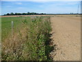
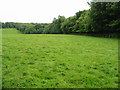
Field edge on the downs
I ended up walking along the edge of this field as the footpath across it had been ploughed up and the signage erroneously pointed this way. This looks back in the direction of Elham. Wick Farm is off to the left.
Image: © Marathon
Taken: 2 Sep 2013
0.15 miles
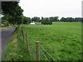
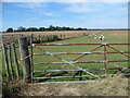
8
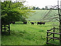
Inquisitive cattle on farmland near Acrise Place
Image: © Nick Smith
Taken: 20 Jun 2008
0.21 miles
9
Sheep on the Kent Downs
These sheep are on the Kent Downs, not far from Wick Farm.
Image: © Marathon
Taken: 2 Sep 2013
0.21 miles
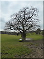
10
Old pit near Acrise Place
There is a larger one to the left of the road, but less visible.
Image: © Robin Webster
Taken: 2 Sep 2017
0.21 miles