IMAGES TAKEN NEAR TO
Acrise, FOLKESTONE, CT18 8LJ
Introduction
This page details the photographs taken nearby to CT18 8LJ by members of the Geograph project.
The Geograph project started in 2005 with the aim of publishing, organising and preserving representative images for every square kilometre of Great Britain, Ireland and the Isle of Man.

There are currently over 7.5m images from over14,400 individuals and you can help contribute to the project by visiting https://www.geograph.org.uk
Image Map
Images are licensed for reuse under creativecommons.org/licenses/by-sa/2.0
Notes
- Clicking on the map will re-center to the selected point.
- The higher the marker number, the further away the image location is from the centre of the postcode.
Image Listing (30 Images Found)
Images are licensed for reuse under creativecommons.org/licenses/by-sa/2.0
Image
Details
Distance
1
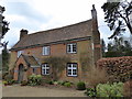
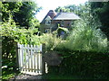
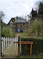
Court Cottage, Acrise
A Grade II listed late 16th and early 17th century building with an 18th century front.
Image: © pam fray
Taken: 23 Mar 2016
0.00 miles
2
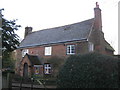
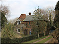
Court Cottage (2)
Grade II listed building on a lane near Village Farm. As seen from the North-west. Has a plaque above the porch, calling it an Historic Building of Kent.
See http://www.britishlistedbuildings.co.uk/en-433554-court-cottage-acrise for more details about the building.
Image: © David Anstiss
Taken: 9 Jan 2011
0.01 miles
3
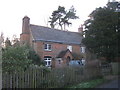
Court Cottage
Grade II listed building on a lane near Village Farm. As seen from the North-east. Has a plaque above the porch, calling it an Historic Building of Kent.
See http://www.britishlistedbuildings.co.uk/en-433554-court-cottage-acrise for more details about the building.
Image: © David Anstiss
Taken: 9 Jan 2011
0.01 miles
4
Old Forge, Acrise
With Valley Farm just down the road. Forge Cottage (and the attached forge) formed part of Acrise Manor Estate, which was broken up in 1929 and the properties on the estate sold as separate lots. Someone has written on my copy of the sale document (dated 25 July 1929) against Forge Cottage and Forge: "Sold to Mrs C A Bailey for £210".
Image: © John Baker
Taken: 10 Feb 2012
0.02 miles
5
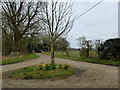
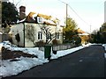
Lanes at Acrise
The track ahead leads to The Old Rectory, to the right the lane leads to Acrise and St. Martin's Church.
Image: © pam fray
Taken: 23 Mar 2016
0.03 miles
6
Oast House at Acrise
Just in case the passer by does not recognise this as a former oast house, the name confirms its historic use.
Image: © Marathon
Taken: 2 Sep 2013
0.03 miles
7
The Oast House, Hoad Road, Acrise
Image: © Oast House Archive
Taken: 14 Mar 2015
0.03 miles
8
Oast House, Acrise
The oast part has been capped by the snow.
Image: © John Baker
Taken: 10 Feb 2012
0.04 miles
9
Oast House, Acrise
An unusual oast house conversion on Hoad Road.
Image: © pam fray
Taken: 23 Mar 2016
0.04 miles
10
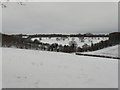
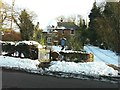
Downland near The Old Rectory, Acrise
The Old Rectory can just be seen in the centre-right of the view. The average depth of the snow was 4".
Image: © John Baker
Taken: 7 Jan 2010
0.04 miles