IMAGES TAKEN NEAR TO
Acrise, FOLKESTONE, CT18 8JY
Introduction
This page details the photographs taken nearby to CT18 8JY by members of the Geograph project.
The Geograph project started in 2005 with the aim of publishing, organising and preserving representative images for every square kilometre of Great Britain, Ireland and the Isle of Man.

There are currently over 7.5m images from over14,400 individuals and you can help contribute to the project by visiting https://www.geograph.org.uk
Image Map
Images are licensed for reuse under creativecommons.org/licenses/by-sa/2.0
Notes
- Clicking on the map will re-center to the selected point.
- The higher the marker number, the further away the image location is from the centre of the postcode.
Image Listing (10 Images Found)
Images are licensed for reuse under creativecommons.org/licenses/by-sa/2.0
Image
Details
Distance
1
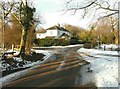
White Lodge, Acrise
The signpost on the corner of Winterage Lane only has one arm remaining - pointing to the Elham Valley. The other arms have fallen off due to their attachments rusting away completely.
Image: © John Baker
Taken: 10 Feb 2012
0.00 miles
2
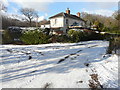
White Lodge, Acrise
The scaffolding, which has been erected on the frontage of this house, may be for the purpose of repairing the render above the roof of the porch.
The snow had fallen, courtesy of “the beast from the east”, between 07:00 and 09:00, earlier in the day, but measured, in an unscientific way with a ruler, only lay to a depth of an inch (2.5 cm) in my garden at Image There was another fall of snow on 2 March but it was very light and hardly made a difference to that, which had already fallen.
This image shows Image during another bout of snowy weather.
Image: © John Baker
Taken: 27 Feb 2018
0.01 miles
4
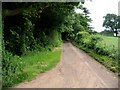
Winterage Lane on the edge of Acrise Wood
Image: © Nick Smith
Taken: 20 Jun 2008
0.08 miles
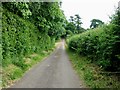
5
Road past Acrise Wood
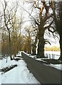
On the left. On the right is a magnificent row of gnarled sweet chestnut trees.
Image: © John Baker
Taken: 10 Feb 2012
0.11 miles
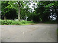
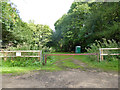
6
Clearing in Acrise Wood
Possibly used by the military, similar to http://www.geograph.org.uk/photo/860380 but there were no obvious 'keep out' signs here.
Image: © Nick Smith
Taken: 20 Jun 2008
0.12 miles
7
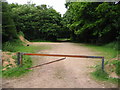
Track in Acrise Wood
As seen from Winterage Lane.
On the right is a troop shelter.
Image: © David Anstiss
Taken: 30 Jan 2011
0.15 miles
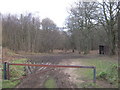
8
Way into Acrise Wood
In the military training area.
Image: © Robin Webster
Taken: 2 Sep 2017
0.15 miles
10
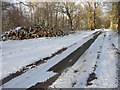
Pile of logs, Acrise Wood
This had been created as a result of Image nearby.
The snow had fallen, courtesy of “the beast from the east”, between 07:00 and 09:00, earlier in the day, but measured, in an unscientific way with a ruler, only lay to a depth of an inch (2.5 cm) in my garden at Image There was another fall of snow on 2 March but it was very light and hardly made a difference to that, which had already fallen.
Image: © John Baker
Taken: 27 Feb 2018
0.22 miles