IMAGES TAKEN NEAR TO
Acrise, FOLKESTONE, CT18 8JS
Introduction
This page details the photographs taken nearby to CT18 8JS by members of the Geograph project.
The Geograph project started in 2005 with the aim of publishing, organising and preserving representative images for every square kilometre of Great Britain, Ireland and the Isle of Man.

There are currently over 7.5m images from over14,400 individuals and you can help contribute to the project by visiting https://www.geograph.org.uk
Image Map
Images are licensed for reuse under creativecommons.org/licenses/by-sa/2.0
Notes
- Clicking on the map will re-center to the selected point.
- The higher the marker number, the further away the image location is from the centre of the postcode.
Image Listing (12 Images Found)
Images are licensed for reuse under creativecommons.org/licenses/by-sa/2.0
Image
Details
Distance
1
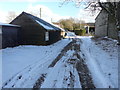
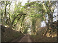
Winterage Lane
Lower Winterage Farm lies on the left side of the lane and Upper Winterage Farm on the right.
The snow had fallen, courtesy of “the beast from the east”, between 07:00 and 09:00, earlier in the day, but measured, in an unscientific way with a ruler, only lay to a depth of an inch (2.5 cm) in my garden at Image There was another fall of snow on 2 March but it was very light and hardly made a difference to that, which had already fallen.
Image: © John Baker
Taken: 27 Feb 2018
0.05 miles
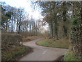
2
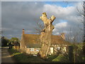
Lower Winterage Farm
On Winterage Lane.
Unknown what large pollarded tree is in the foreground.
Image: © David Anstiss
Taken: 30 Jan 2011
0.06 miles
3
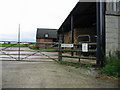
Entrance to Upper Winterage Farm on Winterage Lane
Image: © Nick Smith
Taken: 7 Sep 2008
0.07 miles
4
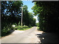
Winterage Lane
This track leads from School Road towards Winterage Farm and onwards to Elham.
Image: © David Anstiss
Taken: 30 Jan 2011
0.11 miles
5
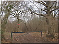
Woodland Track in Pillars Wood
This track leads from Winterage Lane. It is used by the MOD for army training exercises.
Image: © David Anstiss
Taken: 30 Jan 2011
0.16 miles
6
Winterage Lane
Through MOD owned woodland. Pillars Wood to left and Shop Wood to right.
Image: © Oast House Archive
Taken: 10 Jul 2010
0.17 miles
7
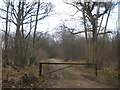
Track in Shop Wood
This track leads from Winterage Lane. It is used by the MOD for army training exercises.
Image: © David Anstiss
Taken: 30 Jan 2011
0.17 miles
8
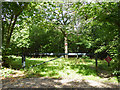
Way in to Shop Wood
But only for the military, according to the red signs.
Image: © Robin Webster
Taken: 2 Sep 2017
0.18 miles
9
Lane junction near Pillars Wood
Pay Street from Densole, meets School Lane, leading left towards Paddlesworth or right to Ridge Row. Winterage Lane leads straight on towards Elham.
Image: © David Anstiss
Taken: 30 Jan 2011
0.22 miles