IMAGES TAKEN NEAR TO
Paddlesworth, FOLKESTONE, CT18 8JR
Introduction
This page details the photographs taken nearby to CT18 8JR by members of the Geograph project.
The Geograph project started in 2005 with the aim of publishing, organising and preserving representative images for every square kilometre of Great Britain, Ireland and the Isle of Man.

There are currently over 7.5m images from over14,400 individuals and you can help contribute to the project by visiting https://www.geograph.org.uk
Image Map (Loading...)


Getting Data...Please wait
Leaflet Map data © OpenStreetMap
Images are licensed for reuse under creativecommons.org/licenses/by-sa/2.0
Notes
- Clicking on the map will re-center to the selected point.
- The higher the marker number, the further away the image location is from the centre of the postcode.
Image Listing (10 Images Found)
Images are licensed for reuse under creativecommons.org/licenses/by-sa/2.0
Image
Details
Distance
1
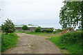
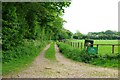
Farm track near Paddlesworth Court Farm
It appears to be mainly access to stables and paddocks.
Image: © Robin Webster
Taken: 22 May 2007
0.06 miles
4
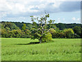
Tree in field, Paddlesworth
A very small pond is mapped here, but it is not obvious.
Image: © Robin Webster
Taken: 2 Sep 2017
0.16 miles
5
Track by Pillars Wood
Also a public footpath. The green sign warns people to keep to the footpath as it runs through Army training ground.
Image: © Robin Webster
Taken: 22 May 2007
0.17 miles
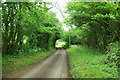
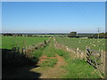
6
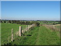
Bridleway to Shuttlesfield
This twin fenced track leads from Paddlesworth. It later passes through large sheep pastures.
Image: © David Anstiss
Taken: 10 Oct 2010
0.20 miles
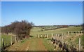
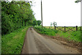
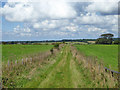
9
Bridleway to Shuttlesfield (2)
This twin fenced track leads from Paddlesworth. It later passes through large sheep pastures. Paddlesworth Court Wood is on the right.
It takes a different (straighter) route than shown on the maps. It follows the track.
Image: © David Anstiss
Taken: 10 Oct 2010
0.21 miles
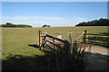
10
Bridleway to Acrise Court
A straightening of the mapped public route, which kinks through the field to the right at first.
Image: © Robin Webster
Taken: 2 Sep 2017
0.21 miles