IMAGES TAKEN NEAR TO
Ethelburga Drive, FOLKESTONE, CT18 8JJ
Introduction
This page details the photographs taken nearby to Ethelburga Drive, CT18 8JJ by members of the Geograph project.
The Geograph project started in 2005 with the aim of publishing, organising and preserving representative images for every square kilometre of Great Britain, Ireland and the Isle of Man.

There are currently over 7.5m images from over14,400 individuals and you can help contribute to the project by visiting https://www.geograph.org.uk
Image Map
Images are licensed for reuse under creativecommons.org/licenses/by-sa/2.0
Notes
- Clicking on the map will re-center to the selected point.
- The higher the marker number, the further away the image location is from the centre of the postcode.
Image Listing (33 Images Found)
Images are licensed for reuse under creativecommons.org/licenses/by-sa/2.0
Image
Details
Distance
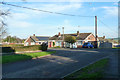
1
Wood Lodge, Brady Road
Planning permission has been approved, with conditions, by Folkestone and Hythe District Council under application number Y17/0625/SH for the “change of use of integral garage to living accommodation and erection of a detached garage with first floor space to be used as a study”.
Image: © John Baker
Taken: 21 Mar 2018
0.08 miles
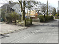
2
Bungalows on Silverlands Road
A turning off Palm Tree Way in the quite extensive enlargement of the village to the north.
Image: © Robin Webster
Taken: 28 Dec 2015
0.09 miles
3
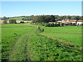
Footpath to Sibton Park
This path leads from Brady Road. Past the Country Club and Longage Farm towards Longage Hill.
The house on the right is Sibton House Country House, used for holiday lets. See http://www.hpb-sibtonpark.co.uk/Default.aspx for more info.
Image: © David Anstiss
Taken: 10 Oct 2010
0.14 miles
4
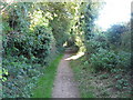
Footpath towards Palm Tree Way
This path leads from Church Road.
Image: © David Anstiss
Taken: 10 Oct 2010
0.16 miles
5
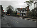
Old Robus, Canterbury Road, Lyminge
Lovely old half-timbered property - and for sale, as well!
Image: © Peter Turner
Taken: 24 Dec 2012
0.17 miles
6
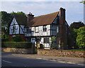
Old Robus, Lyminge
Grade II Listed Building - see https://historicengland.org.uk/listing/the-list/list-entry/1242113
Image: © Ian Taylor
Taken: 7 Sep 2017
0.19 miles
7
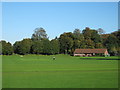
Sibton Park Cricket Club
As seen from a footpath from Brady Road towards Longage Hill.
See http://en.wikipedia.org/wiki/Sibton_Park_Cricket_Club for more details on this old club, established since the 1880's.
Image: © David Anstiss
Taken: 10 Oct 2010
0.19 miles
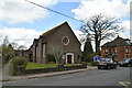
10
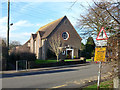
Lyminge Methodist Church
Remarkably modern - dated 1953.
Image: © Robin Webster
Taken: 28 Dec 2015
0.19 miles