IMAGES TAKEN NEAR TO
Springside Lane, FOLKESTONE, CT18 8HN
Introduction
This page details the photographs taken nearby to Springside Lane, CT18 8HN by members of the Geograph project.
The Geograph project started in 2005 with the aim of publishing, organising and preserving representative images for every square kilometre of Great Britain, Ireland and the Isle of Man.

There are currently over 7.5m images from over14,400 individuals and you can help contribute to the project by visiting https://www.geograph.org.uk
Image Map
Images are licensed for reuse under creativecommons.org/licenses/by-sa/2.0
Notes
- Clicking on the map will re-center to the selected point.
- The higher the marker number, the further away the image location is from the centre of the postcode.
Image Listing (130 Images Found)
Images are licensed for reuse under creativecommons.org/licenses/by-sa/2.0
Image
Details
Distance
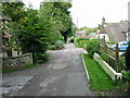
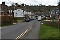
1

Everist Court, Lyminge
A small close leading off Station Road.
Image: © David Anstiss
Taken: 30 Jan 2010
0.03 miles
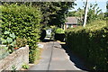
2
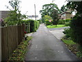
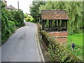
Looking S along Rectory Lane
The long distance path (well 22.5 miles!) the Elham Valley Way follows Rectory Lane on the way to Etchinghill.
Image: © Nick Smith
Taken: 6 Sep 2008
0.03 miles
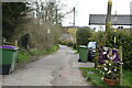
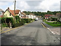
10
Ethelburga's Well on Well Road
The well house is on the site of a spring which is probably the main source of the river Nailbourne which flows through the Elham Valley. The canopy and chain pump were erected in 1898.
Image: © Nick Smith
Taken: 6 Sep 2008
0.05 miles