IMAGES TAKEN NEAR TO
Greenbanks, FOLKESTONE, CT18 8HG
Introduction
This page details the photographs taken nearby to Greenbanks, CT18 8HG by members of the Geograph project.
The Geograph project started in 2005 with the aim of publishing, organising and preserving representative images for every square kilometre of Great Britain, Ireland and the Isle of Man.

There are currently over 7.5m images from over14,400 individuals and you can help contribute to the project by visiting https://www.geograph.org.uk
Image Map
Images are licensed for reuse under creativecommons.org/licenses/by-sa/2.0
Notes
- Clicking on the map will re-center to the selected point.
- The higher the marker number, the further away the image location is from the centre of the postcode.
Image Listing (130 Images Found)
Images are licensed for reuse under creativecommons.org/licenses/by-sa/2.0
Image
Details
Distance
1
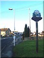
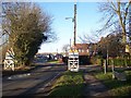
Lyminge Village Sign
On Station Road entering the village.
Image: © David Anstiss
Taken: 30 Jan 2010
0.06 miles
2
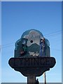
Close-up of Lyminge Village Sign
On a post on Station Road entering the village from Folkestone. The sign depicts Ethelburga, daughter of King Ethlebert (founder of the country's first Nunnery). Behind her a steam engine,(reminder of the old Elham Valley Railway) emerging from St Mary's Church.
Image: © David Anstiss
Taken: 30 Jan 2010
0.06 miles
6
Everist Court, Lyminge
A small close leading off Station Road.
Image: © David Anstiss
Taken: 30 Jan 2010
0.09 miles
7
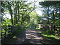
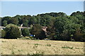
Track bridge near Red House Farm
This track bridge leads from the farm and a byway towards Station Road, Lyminge.
The bridge leads over the disused Elham Valley Railway.
Image: © David Anstiss
Taken: 10 Oct 2010
0.09 miles
8
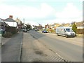
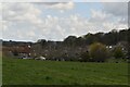
Station Road enters Lyminge
Broad Street from Newbarn becomes Station Road heading into the Village.
On the right is a concrete trough with a plaque on which reads 'Erected by this Council to commemorate the Golden Jubilee of the reign of her majesty Queen Elizabeth II 1952 - 2002'.
Image: © David Anstiss
Taken: 30 Jan 2010
0.10 miles
9
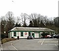
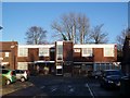
Lyminge station
This station was on the Canterbury West to Folkestone line which was opened by the South Eastern Railway in 1887 and closed in 1947. The station buildings have now been restored and are used as a public library.
Image: © David Kemp
Taken: 17 Mar 2007
0.11 miles
10
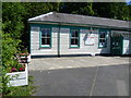
The former Lyminge station
The Elham Valley Railway opened in 1887 and closed completely in 1947. Most of the stations along the line closed to passengers in 1940 but a shuttle service from Folkestone to Lyminge operated between 7th October 1946 and 16th June 1947. The line closed completely on 1st October 1947 and the track through Lyminge was lifted in the late summer of 1953. All the information about the Elham Valley Railway and Lyminge station is given here - http://www.disused-stations.org.uk/l/lyminge/
In the late 1980s the station building, seen here, was renovated and is now Lyminge Library. The platforms were on the far side.
Image: © Marathon
Taken: 10 Jul 2015
0.11 miles